
Subscribe to receive top agriculture news
Be informed daily with these free e-newsletters
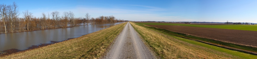
While the Mississippi River crest has yet to move through the Mid-South, it isn’t expected to cause the devastation once feared.
“From what I understand this is the third-highest volume of water on record,” says Arkansas Rep. Rick Crawford. “That’s the bad news.
“The good news is there’s been adequate time to put together a response plan and the levees are holding so far, although we’re very concerned about that. Should those levees be breached, or topped, there would be a quick move to provide as much protection as possible. We’re staying in as close a contact as possible with the (Army Corps of Engineers) and others to make sure everything is ready if a situation dictates.”
As of Thursday (Jan. 7) afternoon, the river was at about 39.4 feet on the Memphis gauge. The National Weather predicted the crest would be at 39.8 on Friday (Jan. 8).
“They’ve revised their forecast down a bit so we’re looking at a slight rise before this is over,” says Jim Pogue of the Memphis Corps district. “The expected crest now is about 4 feet lower than the original forecast of around 44 feet in Memphis. It’ll probably be (around Jan. 15) before we’re done with this.”
Just back from a tour of relief wells north of West Memphis, Ark., Pogue said the wells “are all working well and keeping the underseepage under control. In talking to some Corps guys, they said with the high river in 2011 the area was saturated and wet. This time everything I saw looked nice and dry.”
Relief wells are placed in areas that are prone to underseepage and sand boils due to the natural conditions of the soil.
“One way to deal with that is to put the wells in,” says Pogue. “They’re vertical steel shafts that go down into the ground. That way water isn’t coming under the levee wherever it wants and carrying material away and undermining the levee.
“The water comes up through the relief well in a controlled fashion and it’s then dumped out into a ditch. That water is then conveyed back into the river downstream somewhere or is sent to an area where it can be dissipated. The relief wells act as a kind of pressure valve.
“Things look good in our area for the most part. That’s excluding some spots where there are no relief wells and we’re dealing with some sand boils.”
The next step for Pogue and colleagues is to monitor the river crest as it moves south towards Helena and Clarksdale. Helena was forecast to crest at 49 feet on Sunday (Jan. 10). The crest was expected be in Arkansas City – the next gauge south of Helena – at 45.5 feet next Tuesday (Jan. 12).
“Once the crest passes there the Memphis office will pretty much be done with it,” says Pogue. “The work will then shift to the Corps Vicksburg district.”
What might the weather have in store for the Mid-South?
“The rivers are now largely in decline,” says John Lewis, National Weather Service meteorologist in Little Rock. “Several days ago, following a big rain event in late December, there were close to record crests on the Arkansas River especially the farther west you went. Many sites are now below flood stage except for portions of the White River – the area down toward Clarendon is in that position.”
While there was rain Jan. 7, “that’s now sweeping out of the state and it didn’t amount to much, maybe a quarter- or half-inch.”
As far as the forecast, “the pattern is changing,” says Lewis. “Up to now, we’ve had a very dominant subtropical jet. That’s the wintertime jet that brings us all the warmth and moisture. That’s really driven – especially in an El Nino year like this one – to become especially strong.
That’s what we saw in December with temperatures well above normal – between 6 and 10 degrees. That will likely place this past December as a top three as far as warm Decembers.”
Lewis expects the subtropical jet to become less dominant later in January. “The polar jet – the one that drives cold air into our region from Canada -- will take over for a while. So, we won’t see the warmth we did in December.”
Lewis sees few signs of a huge storm system coming through by Jan. 20 that would cause any flooding. “The rivers shouldn’t be pushed back up.
“Longer term, if the subtropical jet and polar jet phase – in other words, if they come together – we’d have an abundance of moisture along with colder temperatures and that’s the making of a sizable storm. That wouldn’t be out of the ordinary for this type of winter.
“I fully expect to see a major winter storm in the coming weeks. Truly, we haven’t been too far away from that anyway. While the polar jet hasn’t been really dominant, there have been some major winter storms out toward the southern Rockies, New Mexico, the Texas panhandle, and parts of the Southern Plains.
“There are some Mid-Southerners who enjoy winter storms and they may get their wish. Just hang on.”
You May Also Like
Enter a zip code to see the weather conditions for a different location.


