


Subscribe to receive top agriculture news
Be informed daily with these free e-newsletters
June 23, 2011
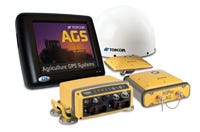 Topcon's System 210 incorporates land-leveling, surveying and field design capability in a package driven by the X20 multifunction touch-screen controller. The system allows field surveys to be conducted directly with the X20 controller, or with a laptop computer with its AGForm-3D field design and survey software installed.
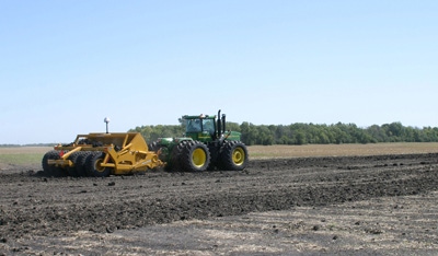
The System 210 GPS and GLONASS-capable real-time kinematic (RTK) package can be configured to drive single or dual scrapers. Currently, it is not set up for ditching or tiling. The system is used mostly in California, Arizona and the Mississippi Delta, where interest in land leveling has been especially strong in recent years, says Ron Cox, regional manager for Topcon.
“In the heart of the Corn Belt, we haven’t seen much interest,” he says. “But we see a big opportunity for land leveling in the Midwest,” either alone or in conjunction with tiling. “A lot of times drainage problems can be solved by just moving a little dirt,” he adds. “This could make tiling systems more efficient, or in some cases eliminate the need completely.”
A complete System 210 water-management package, including an X20 controller, RTK receiver and antenna and tractor-scraper interface retails for $20,500. AGForm-3D retails for $3,000 and a base station, $8,950. For more information, go to the System 210 page at www.topconpa.com.
You May Also Like
Enter a zip code to see the weather conditions for a different location.


