

Subscribe to receive top agriculture news
Be informed daily with these free e-newsletters

A division of Land O'Lakes, Geosys is building on its position with partnerships, technology
June 22, 2016
It's pretty easy to dart from one technology to another in a time of rapid change. The rise of new companies focused on agriculture makes that a challenge. Geosys is no new player to the ag market, but since it moved its headquarters from France to Minnesota a few months ago, its goals of doing more than capturing data have become clear.
"Data is driving a lot of what people are doing today. We talk about the Ag Internet of Things, that's all centered around sensors, yield monitors and collecting data," says Dave Gebhardt, global director of strategic partnerships, Geosys. "Geosys fits into that."
Yet Gebhardt says that the company has moved beyond collecting data moving to "the other end of the data with the algorithms and the ability to take that data to a higher level of value," he says. The aim is to offer the farmer and the agronomist a higher level of value - putting that data to work.
As a wholly owned part of Land O'Lakes, as is Winfield, there's also work to be done on the customer/vendor relationship. Gebhardt is also charged with building partnerships in new segments and more recently he's been busy with new relationships working with others to enhance the data the once satellite-only firm collects.
For example, Geosys is collaborating with SST Software to add in-season satellite imagery for users in North America and Australia through use of the agX Platform. That's a portal where users can seamlessly share data.
Precision farming applications compliant with the agX Platform can access the Geosys in-season imagery program.
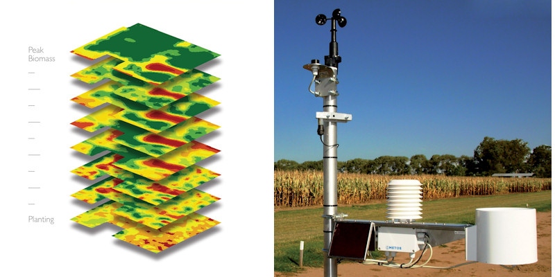
Often when you hear talk of satellite imagery, people bring up its limitations. Yet during the 2015 growing season, Geosys’ Virtual Satellite Constellation delivered an average of more than 15 in-season Normalized Difference Vegetative Index maps per field, across major cropping areas in the United States.
The agX Platform is just one example of how Geosys wants to work with others to share information for improved precision agriculture. "We have a product called Geosys Bridge API- a set of application program interfaces - working with folks on the backside of their branded programs to share information," Gebhardt says. It's that kind of platform that works with agX to share information.
And the Geosys goal of enhancing local data for improved crop management got another bump with a global partnership with Pessl Instruments. The Austrian-based sensor company makes ground weather stations and has created the FieldClimate platform. With the agreement data from the FieldClimate platform can be incorporated into Geosys products including its Croptical monitoring application. Adding ground-based weather information to the data stream from Geosys enhances decision making data available to agronomists about crop health, growing conditions and other key factors.
Remote sensing and crop models
When satellite imagery and data come up in a conversation often questions turn to unmanned aerial vehicles and their role in collecting information. "I believe there's room for drones and UAVs. Remote sensing needs to be thought of as a set of solutions from the ground to the sky including satellites, planes, drones and sensors on equipment. All of those different levels of remote sensing have value to the farmer and their agronomist depending on their specific needs," Gebhardt says.
Yet he notes that all that imagery is just pictures unless they're put to work and where that's going to happen is in combination with crop modeling and measurement. There are already a growing number of agronomic models in use in the market - some to manage inputs like nitrogen, or pesticide application. "Models have a lot of value as a starting point," says Gebhardt. "Another way to look at it is this. Every plant in the field is a sensor itself and represents the current status of that crop in that field. Instead of modeling weather, soil, genetics, or disease, remote sensing simply asks the plants themselves how they are doing."
That satellite imagery provides some local measure in the field and with models built around pests or weather farmers can make better decisions. "That's what we're helping to guide, working on the return on investment with crop and field monitoring tools that can be licensed from us to provide a deep dive into a field, its variability and infestations that may be in that field," he says.
Crop modeling using in-field and in-season data can help a farmer better fine-tune a range of management activities from spraying to fertility timing. Gebhardt adds that much of that work will be with a trusted adviser that enables that work, not limit it.
All this data farmers are collecting will have the most impact when it can be put to work with new decision-making tools that help fine-tune your management. Geosys is working with others in ways to make that a reality. Learn more at geosys.com.
You May Also Like
Enter a zip code to see the weather conditions for a different location.


