Subscribe to receive top agriculture news
Be informed daily with these free e-newsletters

Sentera, a Minnesota firm with a long-history of unmanned aerial system work, has a new service that makes it easier to store, and find, all farm-gathered field imagery.
January 8, 2016
The promise of the unmanned aerial vehicle could be realized in 2016 as the Federal Aviation Administration firms up rules and more farmers and consultants get access to these high-flying tools. Yet the new technology with all its ability to gather information has one challenge: Managing all that data.
Consider the possibility of flying over every one of your fields three or four times a year using different types of imagery - visual, near-infrared, and others - creating a pretty big pile of pictures. How do you not only manage those pictures, but find the images you need when you need them?
There's a new service that aims to do just that. AgVault created by a Sentera, a Minneapolis, Minn., based firm with a long history of UAV experience, is a virtual storehouse of field information that can be geo-located and provides the ability to keep multiple layers of information.
"We have 22 people and 60% are engineers," says Eric Taipale, CEO, Sentera. "Originally many of us were at Lockheed Martin where we worked on the unmanned aerial systems for that company."
And while Sentera does market its own fixed-wing Phoenix aircraft, but has built a significant business marketing imaging sensors to other UAV makers. Sentera has significant experience capturing and working with data.
Greg Emerick, executive vice president, business development, explains that using their equipment the firm and its customers have made 8000 flights (they're FAA approved) and captured 15 million images that make up more than 175 terabytes of data. For those who don't speak computer a terabyte is 1000 gigabytes, or in layman's terms that's a massive amount of data.
Yet using AgVault, the company can find any image it gathered and retrieve it easily. "We found that there's an opportunity in helping to manage this information," Taipale says. "But we stop short of analyzing the data."
The analysis of the yield maps, NIR imagery and other information you gather is the job of other software, Taipale says. He explains that the company learned that getting into that game made this small company a competitor to others that could invest more in analytics. "We can connect to those major analytics programs from AgVault," he explains.
The firm has developed interfaces that allow AgVault to output data to most analytics programs. That way the company could focus on creating a vigorous data management system where you can geo-tag field information to help solve problems.
With AgVault on your Windows computer - with a Web connection - combined with a smart phone app, you can pull together a range of information about each of your fields. For example, say you get imagery from your UAV and see a field spot that has a problem but you're not sure what that problem is.
You could go to that section of the field (AgVault can help you find it on the app), and inspect the field. You can also shoot pix using the Sentera app, which will then send those geo-located images to AgVault and add them as another data layer in the system.
Emerick explains that you can also easily share that information with your trusted adviser (you retain ownership of all the data and Sentera isn't looking at anything). Consider that field-captured photo, easily sent on to your agronomist who can help diagnose a specific problem and perhaps suggest an in-season solution.
"We're platform agnostic," says Taipale. "We don't care what UAV you use, what sensor it has, we just help you manage the data." He adds that when your UAV information goes into AgVault the software converts the information into a format that's more easily managed in the system and shared to other analytics services. Whether you want to kick out a shape file to your AgLeader system or connect information to Field View, there's a way to do this from AgVault.
The program is also designed to allow you to import older data, in any format you have it, so you can get all those images and past information into one place. That process may take some manual tagging so you can get the location right when you load it, but after that your images become easy to find and you can view layers for some quick visual analysis on your own. For farmers with a few years of UAV images already, along with other field imagery, having that information in one place where you can easily export as needed offer some value.
Cost of the new service is $99 per month as a subscription because AgVault does use secure cloud storage for all imagery you capture (though you also have those images on your main office computer too). The subscription includes 100 gigabytes of cloud space, and adding more is available for an additional charge. Learn more at sentera.com.
While Sentera is moving into the data management world with AgVault, it has an active engineering program developing equipment for UAVs including sensors. Greg Emerick, executive vice president, business development, explains that the company offers compact sensors that can offer a range of options.
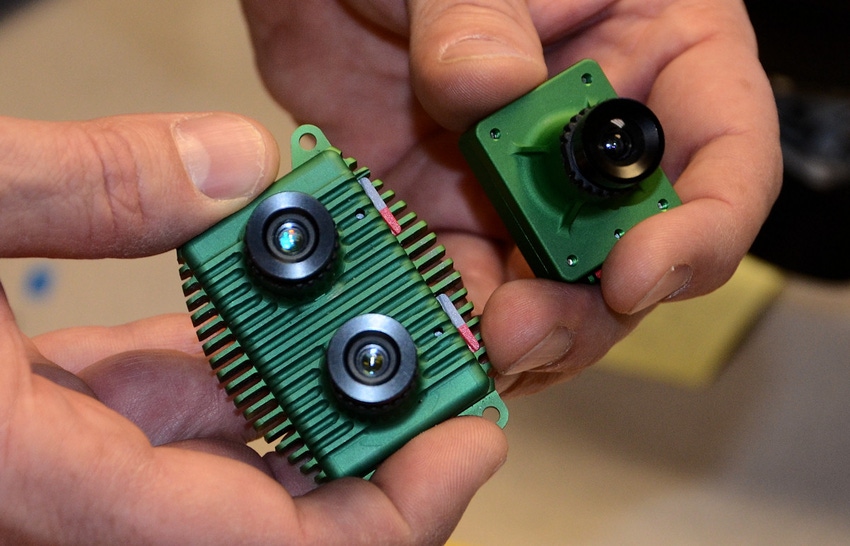
There are three major imaging sensor types the company produces. First is the 28-gram single imaging sensor that can shoot either visual imagery, or near-infrared, but not at the same time. To capture both a color photo and create those popular normalized difference vegetation index maps, you would have to fly the field twice.
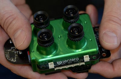
Sentera makes this four-sensor imaging device for UAVs that can capture multispectral imagery offering the potential for a range of interesting ag applications in the future, including the ability to diagnose prob-lems from the air in-season.
The second imaging sensor the company offers has two sensors, so in a single UAV pass you capture both the RGB visual image (RGB for red, green blue - a standard for visual imagery) and NIR. This makes that UAV run more efficient and major drone makers are using the Sentera sensor for that reason.
The third imager is a top-shelf model that can capture multi-spectral imagery. It has four imaging systems on board, it's a little heavier at 126 grams, and right now agronomists and university researchers are investigating what they can capture from the air for advance crop modeling.
Matching specific color and spectral ranges to on-the-ground issues - say weeds or crop diseases - would allow much more detailed aerial scouting for faster field response in the future. Emerick alluded to some research work underway, not yet published, that would offer detailed insight into field issues that would surprise farmers. We'll keep you posted.
You May Also Like
Enter a zip code to see the weather conditions for a different location.