Subscribe to receive top agriculture news
Be informed daily with these free e-newsletters

Too often, El Niño weather patterns fizzle out – what University of Arizona agricultural meteorologist Paul Brown terms as “El Foldo.”Yet the El Niño weather pattern now in place appears to have a better than average chance to deliver above-normal precipitation in the nation's Southwest the remainder of this year than the El Niño’s in recent memory.
May 18, 2015
Don’t get out the umbrellas just yet. University of Arizona agricultural meteorologist Paul Brown is suspicious of wet weather forecasts as are many of you.
“For many years, I have not trusted climate models, yet over the last 3-4 years they’ve done a pretty good job correctly predicting wet weather biases in the Southwest, including wet summer monsoon patterns,” Brown says.
The National Weather Service reports an El Niño wet weather pattern is finally in place – about six months later than expected.
The forecast could at least raise the eyebrows of some growers, perhaps more focused now on making tough, drought-based decisions to economically survive in California, Arizona, New Mexico, and Nevada.
Too often El Niño weather patterns fizzle out – what Brown rightly refers to as “El Foldo.” Yet the El Niño weather pattern now in place appears to have a better than average chance to deliver above-normal precipitation in the nation’s Southwest than the El Niño’s in recent memory.
Specifically, Brown says forecasts from the Climate Prediction Center suggest a bias for above normal precipitation for the rest of this year across Arizona, New Mexico, and parts of Nevada.
Enhanced precipitation is forecast this winter for these same areas, plus Southern California, as a result of El Niño.
Wet odds
“A National Weather Service advisory says there is a 70-percent chance that El Niño will continue this summer and a 60 percent-plus chance that it could continue this fall,” Brown said at the 2015 Desert Ag Conference held in Chandler, Ariz. in early May.
While the linkage between El Niño and spring and summer precipitation is less well defined, the current weather patterns creating wetter than normal spring weather exhibit El Niño-like characteristics.
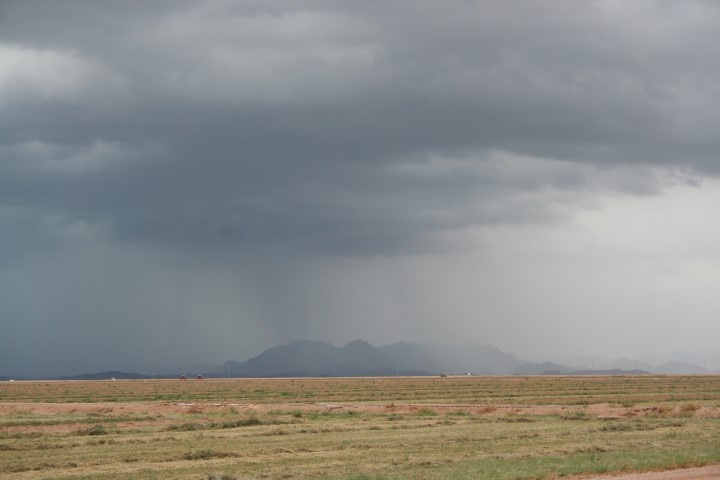
As growers know, rain prospects in the Southwest in late spring and the summer typically are rare at best. In central Arizona, rain in May is as common as a unicorn in red pajamas in a 4th of July parade. Yet three weather systems delivered rare liquid manna during the first half of the month. Temperatures were also cooler.
Brown says the likelihood of the El Niño and related rain and snow could last through the year and through the winter,” Brown said.
Strength matters when it comes to El Niño patterns, the weather specialist says. A stronger pattern can boost rainfall chances while a weak El Niño may produce nothing but a cloud here and there over a sunbaked, drought-choked, furrowed field.
The latest western agricultural news to your Inbox - free Western Farm Press Daily E-Newsletter.
A few models which predict El Niño development call for sea surface temperatures to reach levels which climate scientists would characterize as strong El Niño conditions. Very wet winters have accompanied many strong El Niño’s in the past, including in 1983, 1993, and 1998.
Brown said, “If this El Niño continues to strengthen, it could get pretty interesting weather wise.”
ENSO and PDO
El Niño is one phase of the El Niño-Southern Oscillation, or ENSO, a naturally-occurring event with warming water temperatures in the Pacific Ocean close to the equator. Winter storms tend to enter the Southwest on a more southerly trajectory during El Niño events, leading to wetter conditions.
Brown notes a second factor called the Pacific Decadal Oscillation (PDO), an oscillation of sea surface temperatures off the coast of the Pacific Northwest, which entered a warm phase last year and continues in place. Warm PDO phases have been related to wetter winters in the nation’s Southwest.
“When the PDO and ENSO are warm, there is enhancement towards a wet cycle,” Brown told the audience of pest control advisers, growers, and other agricultural industry members.
Brown says the current bias for a wetter than normal summer, plus the potential for a strong El Niño, could impede crop production and harvests this summer and fall.
“If you are growing cotton, particularly longer-season Pima, it could be an interesting stretch if warm temperatures are matched with an intense monsoon,” Brown said.
Looking ahead to this October through December, Brown says weather models point to continued higher chances for more wetness in New Mexico, the eastern two thirds of Arizona, and into Colorado.
Unfortunately, this wet bias does not extend into Nevada or California until winter.
The climate models even suggest El Niño that could stick around into next year, offering an overall wetness pattern for the southern tier of the states, including the Southwest.
This said, Brown is a realist, knowing good and well that even a strong El Niño can fizzle out. For now though, there is a heightened level of optimism that the months ahead could provide needed rain in the drought-plagued Southwest, a region where overcoming drought too often seems like an insurmountable task.
Time will tell.
You May Also Like
Enter a zip code to see the weather conditions for a different location.


