January 8, 2018

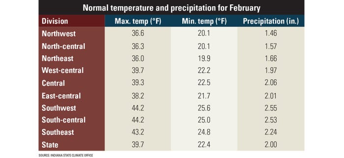
Forget the groundhog! Here’s the weather scoop for February. This information was provided by the National Oceanic and Atmospheric Administration’s Climate Prediction Center. The CPC forecasts up to 90 days out.
Temperature: There is a 33% to 40% chance for cooler-than-normal temperatures in February across most of northern and central Indiana. Odds for a warmer-than-normal, normal or cooler-than-normal month are equal in southern Indiana.
Precipitation: There is a 40% chance the entire state will be above normal for precipitation in February.

National highlights: Cooler-than-normal temperatures are possible across the Great Lakes and into the Upper Midwest, with warmer-than-normal temperatures expected coast to coast in the southern U.S., and even extending up the extreme Eastern Seaboard. Look for a band in between where temperatures could go either way.
A somewhat similar pattern is expected for precipitation, with odds favoring more precipitation than normal in the northern band, and less precipitation than normal across the south and up the Atlantic Coast. The area in between will once again be open to be wetter, drier or normal.
Factors to watch: A weak La Niña event is a player in determining winter conditions in Indiana during the rest of the 2018 winter season. Exactly how strong or weak it is will impact weather trends. La Niña is the cool phase of the ENSO cycle, which stands for El Niño-Southern Oscillation. It is related to changes in surface water temperatures in the tropical Pacific Ocean, which influence atmospheric patterns around the globe. Other factors that influence weather besides the ENSO cycle may also affect Indiana’s remaining winter weather.
Follow changes: Keep up with changes in long-term forecasts at the CPC’s website.
Eggert works in the Indiana State Climate Office. He writes from West Lafayette, Ind.
About the Author(s)
You May Also Like


