Subscribe to receive top agriculture news
Be informed daily with these free e-newsletters

Exceptional drought more than triples area in Arkansas.More counties added to USDA disaster declaration.
July 19, 2012
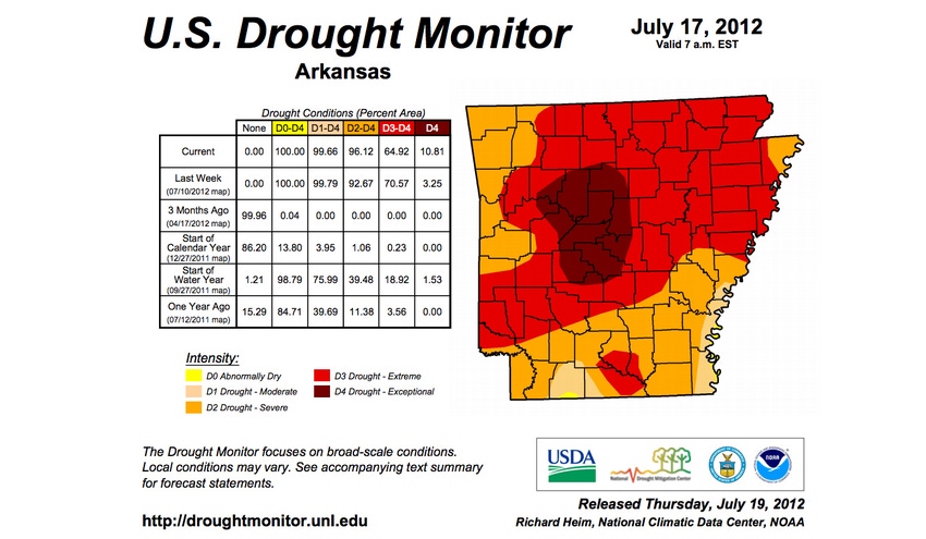
Exceptional drought, the most intense type, has more than tripled its size in Arkansas, according to the U.S. Drought Monitor Map released Thursday.
Exceptional drought now covers 10.81 percent of the state, compared with 3.25 percent in the previous week’s map. The most intense drought covers all of Conway and Perry counties, most of Pope County and parts of Faulkner, Garland, Grant, Hot Spring, Johnson, Logan, Pulaski, Saline, Searcy, Van Buren and Yell counties.
Only Columbia County has the least-severe drought rating, abnormally dry, in a small crescent on the Louisiana border.
Drought could lead to crop delivery problems
Three drought conferences set for southwest Arkansas ranches
Drought’s effects creeping into Arkansas’ irrigated fields
Recent rain allowed the Arkansas Forestry Commission to reduce the wildfire danger slightly from extreme to high and many counties were removing burn bans. However, triple-digit temperatures returned Wednesday, with a record high of 102 set in Jonesboro and highs well past 100 expected Thursday and Friday for most of the state.
Irrigated crops were in good shape, but pastures and range continued to slide, with 83 percent in poor or very poor condition according to the National Agricultural Statistics Service report on Monday.
On Wednesday, USDA added 11 Arkansas counties to its disaster declaration issued last week. They are: Arkansas, Cleburne, Cleveland, Crittenden, Jefferson, Lee, Lonoke, Monroe, Phillips, Prairie, and St. Francis.
For more information on coping with drought, visit Arkansas Drought Resources here or contact your county Extension office.
You May Also Like
Enter a zip code to see the weather conditions for a different location.


