Subscribe to receive top agriculture news
Be informed daily with these free e-newsletters

Think differentAerial images can identify or confirm a problem and its extent.Getting the image is only the first step. The real value comes in specific identification of crop problems by ground-truthing and follow-up plans that make sense economically.In most cases, interpretations and opinions from experienced agronomists or crop advisors are helpful in both correctly identifying and solving problems.
December 26, 2013
Consider a three-way look at your crop — from above and below and at ground level. That means a close-up look at plant roots and soil for clues to plant growth, plus aerial images to detect, confirm, and define a problem.
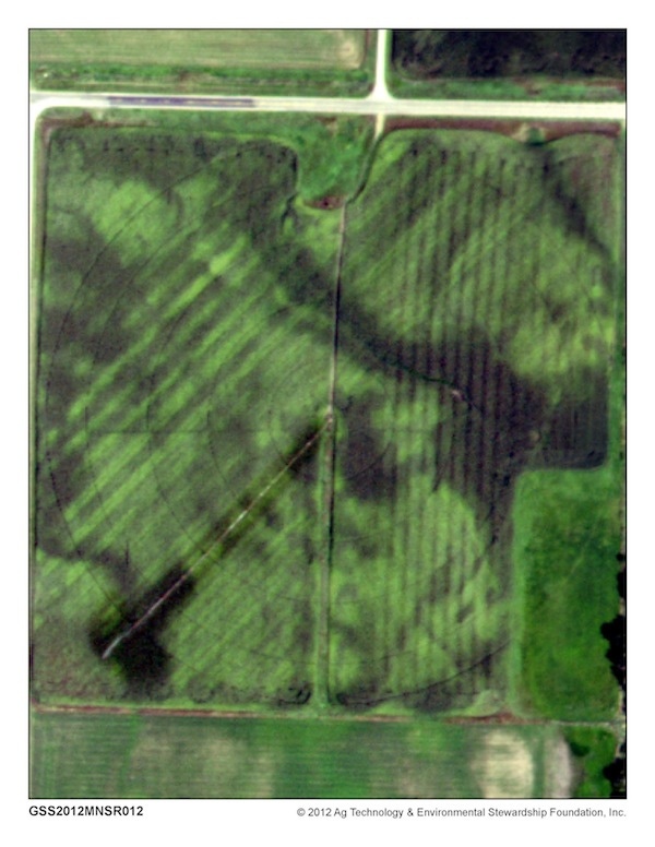
I learn things from aerial images I didn’t pay attention to before,” says David Feldeverd of Melrose, Minn. An example, he says, is how much nitrogen is left in the soil in the second year after he’s plowed down alfalfa.
“I don’t like to over-apply nitrogen, so I follow University of Minnesota guidelines,” Feldeverd says. “But the aerial photos of my land this year show I’m running out of nitrogen in the second year after alfalfa, especially in sandy, irrigated soils. I think they’re giving too much credit to nitrogen from alfalfa in the second year.”
Feldeverd also confirmed a manure drag hose malfunction that left nitrogen-deficient strips. “We thought we could see it in knee-high corn,” he says, “but with the photos you could see it right down to the width of the 24-foot applicator.
“It’s amazing what you can pick up from these photos,” says Feldeverd, who’s in his fourth year of a five-year EQIP contract for water quality improvement on his farm. He’s testing nitrogen use in on-farm strip trials with help from the Stearns County Soil and Water Conservation District and the Iowa Soybean Association’s On-Farm Network.
The aerial photos from GeoVantage are included as part of the cornstalk nitrate test package the Iowa Soybean Association On-Farm Network uses with field strip trials to assess how much nitrogen a crop uses. Feldeverd is one of a 34 farmers enrolled in the Guided Stalk Nitrate Sampling program. A dozen farmers have replicated strip trials. When they get together each December with Stearns SWCD conservationist Mark Lefebvre, the aerial images start the discussion of their nitrogen programs, basal stalk nitrate results and yields. “They’re all pretty interested in the aerial images,” Lefebvre says. The interpretation includes input and guidance from an experienced rep of the On-Farm Network.
Ground-truthing essential
“Aerial images put you in the right part of the field and can give you advance warning to crop problems,” says Terry Panbecker, manager of high-tech Midwest Agronomic Professional Services (MAPS) in Ft. Dodge, Iowa. “Ground-truthing is absolutely essential.” His MAPS technology division is owned by New Co-op in Ft. Dodge and offers precision-ag solutions to ag retailers in several Midwest states.
Crop advisor clients use aerial images to scout fields, assess stands and find or verify prevented planting areas or plant damage from aerial hail and anhydrous, he says.
Panbecker says it’s really not enough to just verify what was happening with aerial photography. “A good agronomist or crop advisor turns the information into an actionable activity that leads to greater efficiency.”
He’d like to see aerial imagery become a regular part of crop production. “I think photos in June to detect plant variation that point out sidedressing needs, photos in July for fungicide and insecticide issues, and photos in late August to help map yield variability would be a very valuable service,” Panbecker says.
Aerial images alerted Austin Allred, a sophomore at Auburn University with seven crop seasons already under his belt, to corn nutrient deficiencies this year. “We saw dark green, middle range green and lighter green spots on the photo,” says Allred, who farms 1,400 acres near Selma, Ala. “When the Selma CPS pulled tissue samples in the lighter colored areas, they didn’t find any nitrogen deficiencies, but they did find magnesium and potash deficiencies. The tissue samples from those areas correlated with yield monitor data, too, so we know the aerial photos are telling us something.”
Brad Smith will pay closer attention to those nutrients as he soil samples now,” says the Crop Production Services branch manager in Selma. “This is my first time using aerial imagery, and I’m just starting to see how valuable it can be. It gives us a target to look at on the ground, rather than just walking through the field.”
Smith says the photos also showed drainage issues on a number of farms, and planter skips on others. “The imagery helps you identify the weak spots in a field,” Smith says.
Aerial imagery costs are half what they were 20 years ago, says tech veteran Terry Pan Becker, manager of Midwest Agronomic Professional Services in Ft. Dodge, Iowa. “Today, you can get software for a few hundred dollars, or some is free, and you can access the imagery with PCs at a1-meter resolution.”
Panbecker also says cameras measure light sources much better for improved tonal and color balance—very important in distinguishing crop differences across a field.
“Now we have the ability to locally geo-rectify several images to look like one photo, and agronomists and crop advisors can get images to the client on an iPad within 3 to 5 days that detect small differences in such things as plant vigor and plant health,” Panbecker explains.
Aerial photos can indicate everything from soil types to hybrids’ drought resistance to different soil-fill depths on reclaimed coal-mined land.
Seek local experts
“Growers can come to us directly for their imagery, but our suggestion is to go to their crop advisor, agronomist or co-op,” says Nate Taylor of GeoVantage, a major supplier of imagery across the Corn Belt. “You need someone strong in agronomy to take our imagery and data and turn it into a recommendation.”
Taylor has seen a dramatic increase in use of remote sensing for scouting and other management in the past 3 years and sees even more adoption in the future. “Before, you had to walk across the field,” he says. “But now local crop advisors can get fast delivery of high quality images to save time and be more accurate. With more consolidation and larger farms, managers are asking how they can leverage technology for greater efficiency,” Taylor says.
Low-resolution images mask crop variability, Panbecker says, but higher resolution images that zero in on small areas cost more. “It’s cost effective to first think through your goals. That will help you decide if you need quick turnaround, and what resolution you need,” he says. He recommends cloud-free images, usually from low altitude flights.
Other recommendations:
1) Find a supplier that can produce data that makes the photos meaningful agronomically and economically.
2) Ground truth the aerial photos to confirm what you think you see in the photos.
3) Use a supplier who will help develop an action plan based on imagery and ground-truthing to overcome crop problems identified
You May Also Like
Enter a zip code to see the weather conditions for a different location.


