There is weather and there is climate. Understanding both allows farmers to make better disease management decisions.
Weather is the condition of the atmosphere measured as temperature, humidity, precipitation and etcetera over minutes, days or a few weeks. Climate is the average daily weather over an extended period. It’s more intuitive to make management decisions based on current conditions and local forecasts. It’s harder to incorporate the complexity and day-to-day uncertainty of climate. However, climate has a tremendous impact on agriculture and with deeper understanding comes better, more-informed decisions about production practices.
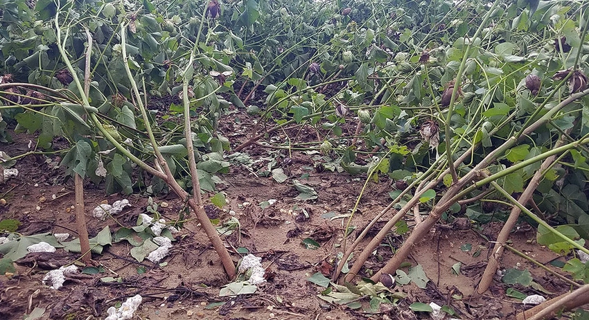
Just now I received a message from cotton farmer Burlin Findley in Jay, Fla. It is an image of his cotton strewn across the field following Hurricane Zeta. It is the hope of all in Extension that with a better understanding of the impact of climate on crop production, we can find ways to better protect farmers like Burlin from its devastating effects.
La Niña
In my wheelhouse as an Extension plant pathologist, there are three major forces that affect our climate: a) seasons, b) ENSO phases, and c) warming. Growers typically incorporate climatic conditions based on season of the year into their crop production plans. An understanding of seasonal climate allows you to make informed decisions on planting dates to reduce risk to seedling diseases, to increase germination and seedling vigor, to harvest ahead of frost and to take advantage of anticipated summer rains.
A second predictable force impacting climate is the El Niño–Southern Oscillation. ENSO phases (El Niño, a La Niña, or a Neutral) are tied to variations in temperature of the surface of the tropical eastern Pacific Ocean and in air surface pressure in the tropical western Pacific.
UGA agricultural climatologist Pam Knox notes, “We have just entered a La Niña phase. It is expected to be a strong one and will last through the winter and into spring. Climatologically that means warmer and drier than normal conditions are expected over the winter. Even so, we could get some cold spells; that is normal even in a La Niña winter.
"Warmer temperatures will lead to more overwintering of pests and diseases. The strongest La Niña signal occurs in southern Georgia, Alabama, and down into Florida, but it should be warmer and drier than usual throughout the Southeast," she said.
In preparing for 2021, remember a warmer winter allows nematodes to remain active longer, thus increasing populations and could delay a killing-frost to eliminate plants harboring diseases and nematodes. A drier winter will slow the degradation of crop debris that harbors disease-causing fungi and bacteria.
As I write, rains from Hurricane Zeta flood the street outside my office. At the end of September, I used Twitter to share images of harvest delayed as peanut pickers sat silently in the rain. A learned colleague replied to my tweet with encouragement that, “… Tomorrow will start a good stretch of fall-like weather (cool and dry).… This is the harvest weather we have been waiting for.”
Having experienced the passage of Hurricane Sally, I was hopeful, but my optimism was short-lived. By Oct. 9 we received winds and rain from Hurricane Delta and on Oct. 28, the same from Hurricane Zeta.
Natural Variability
According to Knox this year’s active tropical season has been due to a number of factors. She states,” It was a neutral ENSO year until the last month, and those years are generally associated with more Atlantic activity due to the lack of a strong subtropical jet stream that blows the top off of developing storms. We also have above-normal sea surface temperatures (SST), which are related to the globally warming temperatures, and this has made the development of tropical waves into storms more likely. So you can partially attribute this year’s activity to a warmer earth, but part of it is just natural variability, too.”
She continues, “The research on how a warmer climate will affect hurricane seasons is mixed. The general consensus is that we are not sure if the number of hurricanes will increase, but that the ones that do form are likely to be more intense (due to warmer SST) and slower-moving, which means more impacts from heavy rain. They could intensify more quickly (like Michael and Laura) due to the warm water, too. “
Now in the Philippines, farmers await the second major typhoon in days. Super typhoon Goni threatens the lives and livelihoods of many, to include those of my adopted “family” and destruction of their small store built from bamboo and palm-thatch. Typhoon Molave displaced an estimated 250,000 Filipinos and left at least 16 dead, 13 missing, and 10s of millions of dollars in crop losses. Rice harvest was at its peak in some areas when the storm pummeled them; super typhoon Goni will further punish the Filipinos this weekend.
Although they are in small, far-away villages, each of you who support Southeast Farm Press has helped some severely affected by typhoons. The editors here know that every penny of the stipend I am provided is used to replace roofs, fix damaged homes, and to send children to school. They in the Philippines are thankful to you and to Southeast Farm Press for such generosity.
About the Author(s)
You May Also Like


