

Subscribe to receive top agriculture news
Be informed daily with these free e-newsletters

Corn, soybean ratings continue to slide lower.
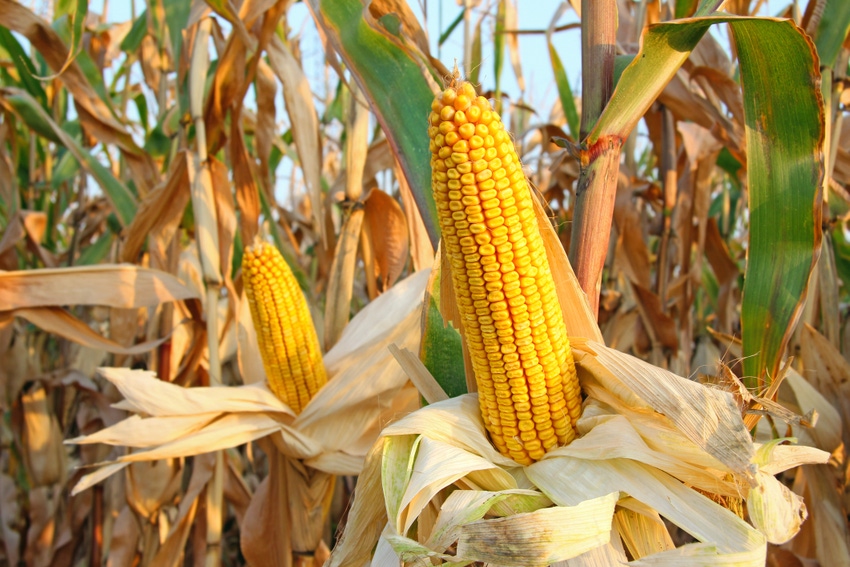
Corn conditions in Farm Futures’ Feedback from the Field series slipped last week as hot and dry weather scorched the battered crop and rains from Hurricane Laura over the weekend may have been too little too late, according to FFTF respondents.
“Very dry all of August until the 28th. Over 6" of rain in 12 hours,” a Central Wisconsin reader shared. “Unfortunately, rain came after substantial yield loss.”
A Central Illinois farmer echoed the sentiment as dry conditions intensified in the northern half of the Prairie State, noting area corn crops are “Deteriorating with continued heat and lack of moisture. Shallow kernel depth will be a major factor on overall yield.”

Yesterday’s updated corn condition ratings in USDA’s weekly Crop Progress report came in exactly as analysts and traders expected – lower. Consecutive weeks of hot and dry weather took a toll on crops that had withstood any significant damage from the August 10 derecho wind storm, driving the national corn crop rating down 2% from a week ago to 62% good to excellent for the week ending August 30.
Iowa farmers continued to report struggling crop conditions. “Fuller season crops can still benefit from cooler temps and rainfall here, but the big yields are gone,” said one. “The heat and wind have taken a lot of the green out of the corn plant the past 2 days. [It’s] extremely dry,” noted another last Wednesday.
The heat and lack of rainfall continues to speed up corn development, suggesting that harvest may start sooner rather than later this year, weather permitting. The majority of the nation’s corn crop (94%) is well into the dough phase as of Sunday, with another 63% of corn acres reaching the dent stage, up 7% from the five-year average. About 12% of the crop has matured as the hot weather dries down stalks, 2% ahead of the five-year average.

Hot and dry weather torched yield potentials as reports of pods aborting and plants wilting in the sun filled the Feedback from the Field inbox last week. Hurricane Laura did few favors to soybean crops in the South , where high winds twisted crops. While yield losses are not expected to be significant, farmers will have to navigate higher likelihoods of lodging, which could slow harvest paces.
An Iowa reader was already seeing signs of crop maturation, noting that the “early beans starting to turn. [It’s been] very dry. [We’ve] had about 1 in. of rain last 30 days.” A Wisconsin FFTF respondent was already forecasting reduced yields and slowing harvest paces, lamenting that “much of the beans are lodged after 6" of rain and high winds in 12 hours on the 28th. [We] lost substantial yield from dry weather before the rain.”
“Recent rains are filling pods, [but we] don't know how much we got hurt from bloom drop or aborting of pods during our 3-4 weeks of dry weather,” a Kentucky grower worried.
Soybeans, which have largely withstood this summer’s growing conditions better than corn, were downgraded in yesterday’s weekly Crop Progress report. USDA lowered soybean ratings 3% from last week to 66% good to excellent for the week ending August 30.
Another Iowa farmer pointed out that there may be some hope for beans planted later in the season. “Any varieties that are not R7 growth stage can benefit from rainfall and cooler temps. But the top end is gone.”
The majority of soybean acres across the country finished setting pods during the aforementioned heat wave, which could lead USDA to downgrade yield potential for the 2020 soybean harvest. About 95% of soybean acreage had set pods as of Sunday and 8% had reported dropping leaves, which was in line with the five-year average. Similar to corn, the heat stress from the past few weeks will likely speed up soybean maturation time tables eventually leading to an early harvest.
Hard red winter wheat will likely finish up this week in Montana and the Pacific Northwest. U.S. Wheat Associates estimate the harvest to be over 95% complete as of Friday. Estimated test weights are slightly higher than the five-year average at 61.5 lb/bu. Cool nights and irrigated fields slow to mature may stall progress, but warm and clear days forecasted ahead should not slow HRW harvest significantly.
Soft white spring and winter wheat harvests were about 75% complete as of Friday, with harvest paces for the winter crop ahead of the spring sowing in the Pacific Northwest. Early protein estimates project the crop to contain 9.7% protein, down from 10.0% a year ago, which is good news for white wheat growers. Hot and dry weather next week should help harvest progress continue at a steady pace.
With hard red spring harvest nearly 60% and durum harvest 33% complete, this afternoon’s completion rate for spring wheat harvest should steadily increase from 49% complete a week ago, especially after a week of mostly warm and dry weather. Cooler temperatures at night in Montana and North Dakota could slow harvest paces as the last of the spring wheat matures, though overall yields and quality ratings are good as the Northern U.S. closes in on the second half of spring wheat harvest.
One North Dakota Farm Futures reader noted crop damage due to recent weather events as combines started rolling. “Hail damage 1 week before harvest,” the farmer reported.
Spring wheat harvest continues to play catch up with historical averages after a slow start. Yesterday’s Crop Progress report found 69% of spring wheat acreage was harvested as of Sunday, up 20% from a week ago as dry weather conditions in the Northern U.S. aid in harvest progress. But spring wheat growers closed in on the five-year average of 77% for the same time period. This week, growers were only 8% behind the five-year mark despite being 13% behind a week ago.
Pastures remain dry across the country as 57.62% of U.S. acreage roasts in varying stages of dry weather and/or drought. Pasture and range conditions fell 2% from last week to a mere 22% good go excellent as of Sunday. “Spring and summer grass is real dry,” a Kansas rancher fretted. “Too dry to trigger fall grass growth.”
Cooling temperatures forecasted in NOAA’s 6 to 10 day outlook will help alleviate some heat stress, though much of the damage is likely already done. Early September forecasts have a 50% - 90% likelihood of being lower than average as fall approaches.

But dry weather will likely continue into the harvest season, accelerating crop maturation rates. The chances for above average rainfall range between 33% - 50% in the Eastern Corn Belt and Southern Plains next week, but dry weather will persist in the parched Northern and Central Plains. And the bad news doesn’t stop there – NOAA’s shows below average chances of precipitation rising into areas of the Eastern Corn Belt late next week.

Feedback from the Field Roundup – Week ending Aug. 23, 2020 - A closer look at derecho crop damage sends corn ratings tumbling.
Feedback from the Field Roundup: Week Ending August 9, 2020 - Dry conditions expected to be exacerbated by yesterday’s derecho winds.
Feedback from the Field Roundup: Week ending August 2, 2020 - Wheat harvest rolls on in the Northern U.S.
Feedback from the Field Roundup – Week ending July 26, 2020 - Improved corn conditions offset drought, wind damage.
Feedback from the Field – Week ending July 19, 2020 - Crops withstand the heat while pastures and rangeland suffer lowest ratings since 2012.
Feedback from the Field: July 7, 2020 - Crops stand up to hot weather – for now.
Feedback from the Field: June 30, 2020 - Despite strong ratings, the corn crop may face challenges during silking process.
Feedback From The Field: June 23, 2020 - Readers report solid corn and soybean crop quality so far this year.
You May Also Like
Enter a zip code to see the weather conditions for a different location.


