

Subscribe to receive top agriculture news
Be informed daily with these free e-newsletters

Flying the drone is actually the easy part. It's making the connection from the data into something you can use.
When an image of a field causes a grower to ask more questions, that’s when they can improve.
“If you’re questioning what you’re doing, then you are looking for a better way and if you can measure it, you can make it better,” said Brandon Batten, Johnston County, N.C., tobacco farmer and drone operator.
One way farmers and ranchers are calibrating management decisions on the ground is from the air using unmanned aerial vehicles (UAVs) or drones. Batten, also a corn, soybean, rye, wheat, and cattle farmer, utilizes drones to conduct stand counts and develop fertility plans for his small grain crops.
“Last spring after we transplanted tobacco we got 13 inches of rain in a 10-day period. We had a lot of drowned tobacco, a lot of washed-out fields,” says Batten. “I was able to use the drone to do stand counts before I could even walk in the field and assess the damage.”

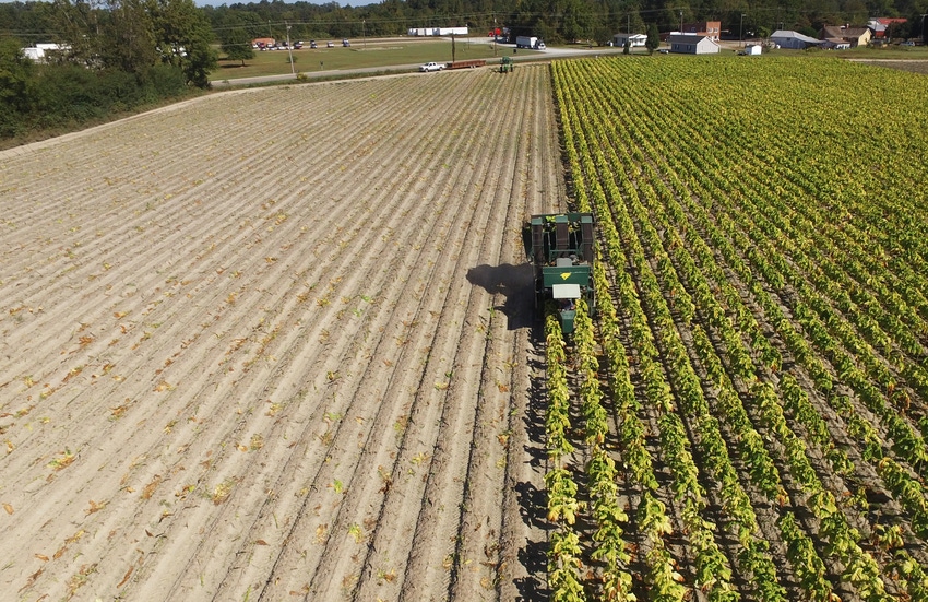
Brandon Batten flies his drone over his soybean crop in Johnston County, N.C.
Though flying drones still takes time, Batten credits the technology for allowing him to zero-in on any crop issues. “I can quickly see where the problem is and go there as opposed to walking the whole field and maybe finding the problem or maybe not,” says Batten. “So, it's allowed me to dial in exactly where I need to be looking, figuring out what's going on: is it a soil type issue, a drainage issue? Is it a carryover chemical issue? You can see so many patterns when you get up 400 feet above your fields that you really can't see walking in them.”
New Platform
The market size for drones in smart agriculture is predicted to increase from approximately 670 million U.S. dollars in 2015 to 2.9 billion U.S. dollars by 2021, according to a report on statistica.com. And while aerial imaging is not new to agriculture, the use of drones is allowing growers to access a closer look, even on an individual plant basis, in a short-amount of time.
“A drone is basically just a new platform (with obvious advantages) to collect the same sort of data that we've been collecting from airplanes and satellites for decades,” says Lori Duncan, Tennessee Extension specialist in biosystems engineering. “It does allow us to have much higher spatial resolution and we can fly more often which changes the game. The challenge lies in interpreting the data into a meaningful agronomic decision.”
Historically, satellite images have been used to give growers a birds-eye view of their crops, providing a resolution of 30 meters. UAVs allow growers to zoom in even closer. “With these drones, there's not a limit on our spatial resolution, so when we fly I can get down to an inch in resolution,” says Duncan, who uses drones to conduct applied research. “It's a lot of data but because we've come into this era of precision agriculture, it’s hard to make precise recommendations on a 30-meter pixel. And if we're talking about making any site-specific applications — be it fertilizer, pesticide or whatever — it’s really hard to make any kind of educated guess on that 30-meter image, whereas if we’re down at the sub-inch level we can really see if it's a weed or if it's the cotton plant.”
UAVs can be used to view live images or they can be armed with sensors that allow them to detect and map areas of pressure in the field. “We can generate a map that will show where in the fields these regions of pressure are,” says Dr. Bobby Vick, solutions engineer at PrecisionHawk, Raleigh, N.C. “We don't prescribe to the farmer how much product he or she should apply but we can help them target where those locations of stress are in their field — be it fertility, be it disease, or otherwise. Then they can use that information to create management zones."
How Many at the Party
Once those zones are determined, growers then have the information they need to make more precise decisions. “We can fly certain crops at early stages of development and detect individual plants where they’ve emerged in the field and give growers and researchers an idea where their stand is at in the field,” explains Vick, who adds that while agriculture is his company’s bread and butter, they also work with other industries including energy, insurance, construction and civilian government applications.
“If I'm going to host a party, it's not how many people I invite to that party that I care about, it's how many people actually show up to that party because that's the number of mouths I've got to have food and drink for. The same is true with your fields. Your farmer doesn't necessarily care how many seeds he or she put in the ground — that's a starting point — but what's more important is how many of those seeds actually emerge and how many of them are viable plants that can produce fruit or a harvest. Whether it's plant counting or looking at canopy cover or even the vigor of the plant, we can help farmers make a mid-season determination of what the yield potential of that field is so they're better informed in terms of managing inputs that go into that field later on, whether that's nutrients water or what have you.”
Irrigation management is another area taking advantage of drone technolgy. “They can fly the field with a thermal sensor and see hot areas or where the plant has stopped transpiring and is getting hotter and needs to be irrigated,” says Duncan.
While new technology can be helpful it can also be intimidating. According to Batten, who also owns a drone company Flying Farmer LLC, N.C. He says growers contemplating using drones should, “just do it.”
“Flying the drone is actually the easy part, it's making the connection from the data into something you can use,” says Batten, who helps growers interpret their data. “You don't have to have the most expensive drone. You can do a lot of what I'm doing for fairly cheap -- $1,500 maybe a lot of money but in the farming world that's not a lot of money on a piece of equipment.”
Batten advises growers to purchase more batteries than they think they’ll need and to allow time to transfer the data. “These images are high resolution, a huge amount of data, so if you're like me and don't have great internet it can take a long time to upload the images to be processed. I'm allowing an extra day if I fly a field this afternoon. I'll go home and start uploading the images and if I'm lucky it'll be done in the morning and I can start doing something with it. Lack of infrastructure or broadband internet is a challenge that I that I have to plan for.”
To operate a drone for commercial production, a grower is required by FAA to obtain a license. “If you are using a drone to make any kind of management decisions on your farm you're supposed to have a license with FAA.”
In addition, while operating that drone, it must be within view. “If your using a UAV and you are licensed, it cannot go out of your visual sight,” says Duncan. “Even though you can live feed a camera back, you have to be able to look up in the sky and see the drone, so if you're inspecting anything, be it a fence line or whatever, be aware that that's a rule.”
For more information about FAA rules and regulations, go to https://www.faa.gov/uas/faqs/.
You May Also Like
Enter a zip code to see the weather conditions for a different location.


