May 7, 2019
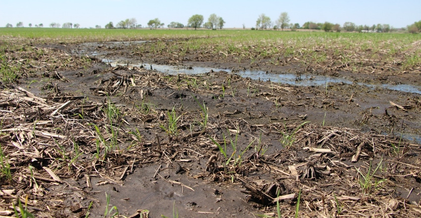
The latest weekly USDA survey released May 6 shows Iowa farmers now have 36% of the state’s 2019 corn crop and 8% of the soybeans in the ground. For corn, that’s one day behind last year and five days behind the five-year average. “This cool, wet spring continues and has everyone running behind schedule,” says Don Lembke, who farms near Storm Lake in northwest Iowa.
Many areas of Iowa had cool, wet weather last week, creating unfavorable field conditions. “It looks like our wet weather woes will continue for the next few days,” notes Iowa Secretary of Agriculture Mike Naig. “The forecast for this week is for more rain, which will create more planting delays, especially in the northern parts of the state.”
Nationally, USDA pegs corn planting at 23% complete, which is lagging significantly behind the five-year average of 46%. Illinois farmers have only 10% of their corn planted, way behind their 66% average for the past five years. Indiana farmers have just 3% of their corn planted versus a five-year average of 35% for early May. USDA says only 6% of the 2019 U.S. corn crop has emerged, versus a 13% five-year average.
The complete weekly Iowa Crop Progress and Weather Report is available on USDA’s site at nass.usda.gov/ia.
Crop report
Rain across Iowa delayed planting and held Iowa farmers to 2.8 days suitable for fieldwork for the week ending May 5, according to USDA’s National Ag Statistics Service, which conducts the weekly survey. Below-normal temperatures also slowed crop emergence.
Topsoil moisture levels rated 0% very short, 2% short, 69% adequate and 29% surplus. Subsoil moisture was 0% very short, 2% short, 66% adequate and 32% surplus.
Statewide, just 15% of the corn crop was planted during the past week. Iowa growers have now planted 36% of the expected 2019 corn crop in the ground. That’s one day behind last year and five days behind the five-year average. Northwest and northeast Iowa farmers have less than 20% of their corn planted. Only 1% of the Iowa crop has emerged, almost a week behind average.
For soybeans, 8% Iowa’s expected 2019 crop has been planted, two days behind last year and two days behind average. The survey shows 88% of the state’s oat crop has been planted, six days ahead of last year and equal to average. And 35% of the oat crop has emerged, two days ahead of last year but a week behind average.
Pastures have had plenty of moisture, but they could use warmer temperatures as growth remains slow. Pasture condition is rated 61% good-to-excellent. Even with the slow pasture growth, cattle have been turned out into pastures.
Weather summary
According to Justin Glisan, IDALS climatologist an active rainfall pattern brought unseasonable wetness across southeast Iowa during the week ending May 5. Measurable rain was reported every day; the highest totals were along the Iowa-Illinois border. The rest of Iowa was near normal to around an inch below average for the week. Statewide average temperatures were also unseasonably cool.
Showers and thunderstorms swept across Iowa late Sunday evening (April 28) and exited Iowa during the morning on Monday. An isolated severe thunderstorm quickly moved from southeast Iowa into central Iowa, leaving behind dime to quarter-size hail from Madison to Polk counties on Sunday evening. Late in the day on Monday into Tuesday (April 30), a low-pressure system advanced through the state.
The low brought a widespread area of moderate rainfall over the southeast third of Iowa for much of the day. Rain totals through 7 a.m. Wednesday (May 1) exceeded 1 inch at 21 stations, with Burlington (Des Moines County) reporting 2.94 inches. Three other weather stations observed totals above inches.
As the low moved out of the state, rain showers formed across northwest Iowa and remained into the early morning hours of Thursday (May 2). Average high temperatures for this period were in the upper 40s to low 50s, or 10 to 15 degrees below average.
Compared to the beginning of the week, Friday (May 3) through Sunday was generally pleasant with spotty areas of rain each day. The weekend began with a light rain moving across portions of west-central Iowa before they dissipated in late morning on Saturday. Under sunny to partly cloudy skies, highs were in the upper 60s to low 70s, with light wind. Rain showers moved through the same regions late Saturday into Sunday, while overnight lows remained in the low to mid 50s.
Weekend rain totals were highest in the western part of the state with light accumulations into central Iowa. Des Moines (Polk County) reported 0.03 inch, while Underwood (Pottawattamie County) had 0.62 inch.
Statewide average precipitation for the week ending May 5, at 1.15 inches, was above the normal of 0.98 inch. Temperatures also averaged 50.6 degrees, 4.4 degrees below normal. The week’s high temperature of 75 degrees was at Atlantic (Cass County) and Little Sioux (Harrison County) on May 4, 6 degrees warmer than average. Fayette (Fayette County) reported the week’s low temperature of 25 degrees on May 29, which was 15 degrees below average.
Rain totals ranged from 0.21 inch in Dakota City (Humboldt County) to 4.41 inches in Salem (Henry County). Ten National Weather Service stations reported totals above 4 inches.
About the Author(s)
You May Also Like


