Subscribe to receive top agriculture news
Be informed daily with these free e-newsletters

The next phase of work being conducted by the United States Geological Survey will involve gathering specific data about the Mississippi River Valley Alluvial Aquifer and evaluating all solution scenarios that could lead to its recharge.
In what has become a massive, multi-organizational and multi-state effort to save the Mississippi River Valley Alluvial Aquifer (MRVAA) as a viable water source for generations of future farmers across the Mid-South, Dr. Jeannie Barlow, program officer, Lower Miss., Gulf Water Science Center, U.S. Geological Survey (USGS), updated those attending the Delta Council’s recent mid-year meeting on the latest work being conducted in this effort.
Started in 2017, the Mississippi Alluvial Plain project is now in a “dual” data collection phase. The first phase, a monitoring network organized through a task force within the Mississippi Department of Environmental Quality (MDEQ), continues to gather critical water use data through a voluntary metering program. The USGS is leveraging this broad network through 20 sites set up with instruments to collect additional data on a real-time basis.
“Data from these sites will allow us to discern when wells are cut off and on, as well as how much water they are delivering,” explains Barlow, who stressed to those at the meeting the necessity of having precise data to place into the model being used to create a variety of potential solution scenarios. “The better the data we are able to gather for the model, the more accurate the model will be in providing us viable options.”
The second phase of data collection involves being able to understand more clearly the hydrogeologic framework of the MRVAA, an aquifer that stretches south from Cape Girardeau, Mo., to Natchez, Miss., and laterally across parts of Arkansas, west Tennessee, and eastern Louisiana.
“Think of the hydrogeologic framework of the aquifer as its fabric — what it’s made of, the subsurface materials that comprise the very texture of what the water is carried through,” adds Barlow. “The aquifer’s texture determines how easily water can travel through it. To better understand that texture, we’re employing some methods like those used on humans when they undergo a Magnetic Resonance Imaging (MRI) scan.”
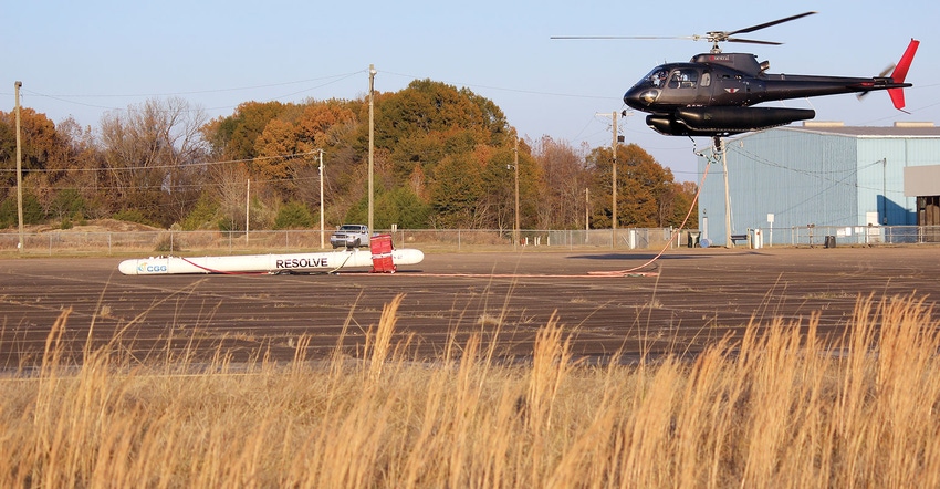
A patchwork of crisscrossing low-level helicopter flights, currently being flown out of the Greenwood-Leflore County Airport, began this month and will continue at various fixed-based operations across the Mid-South, until the entire aquifer has been mapped. A resolve sensor, called The Bird, is suspended below the helicopter and emits an electromagnetic field and radio waves down through the surface of the earth. Information obtained via the bird will be used to generate multi-spectral maps.
“These maps will allow us to understand the various properties within the aquifer at depth,” explains Barlow. “We can then take that information, as well as the other related information we’ve been gathering, and create the basic fabric of our model.”
Information gathered during these airborne geophysical survey flights will provide Barlow and the team other benefits related to the multi-faceted project. From more efficient management of available resources and specifics about the project in general, to a better understanding of things like aquifer recharge and how ground water and surface waters interact, the survey flights will give scientists a direct look into the heart of the aquifer. Anyone wishing to follow what areas have been flown and what areas are scheduled to be flown may do so by logging on to https://bit.ly/2AucXu6. “Survey aircraft will fly only during daylight hours and will not fly directly over buildings or populated areas at low elevation,” assures Barlow.
There is no one silver bullet for solving the problem associated with the depleting water levels of the aquifer. There is also no quick fix. The projects being considered range in design, complexity, and cost. “We evaluated alternative water supply scenarios a year ago and decided what could be modeled,” says Barlow. “We had to assess what information was already available to us and feed it into an economic model to determine the potential cost for each plausible project.”
Projects under consideration to improve the status of the aquifer are varied and include decreasing groundwater withdrawal, increasing irrigation efficiency and tailwater recovery, improving on-site storage, inter/intra-basin transfers, or groundwater injection.
“We modeled each of these various scenarios and compared them to a base scenario,” explains Barlow. “We were then able to determine what the water level responses were for each option. That information was then entered in our economic model which generated a ‘cost per-foot of water level’ response for each scenario. This type of information will help us make a more informed decision about what project to pursue and what step to take next — always keeping our eyes on maximizing resources and minimizing costs.”
Overall results suggest that the Instream Weirs program results in the lowest costs of implementation measured as cost in dollar per-acre foot of reduced pumping from the aquifer among all scenarios, followed by the RISER program. “The other alternatives resulted in various levels of implementation costs depending on the location of the project and adoption rates by producers,” explains Dr. Lawrence Falconer, economic professor, Delta Research and Extension Center.
In 2014, Dr. J.R. Rigby, research hydrologist, USDA/ARS, was contacted by an Arkansas farmer who had seen water going down a home-site well and wondered why water could not just be injected back into the aquifer rather than waiting on Mother Nature to recharge it.
Rigby and Arkansas collaborators Michele Reba, USDA, and John Czarnecki, USGS, quickly set up a few transducers to monitor the crude injection attempt, but it was no surprise that water pumped underground from a well across the farm cascaded down the abandoned well and back into the aquifer as easily as it came out.
“This isn’t the proper way to recharge the aquifer on a long-term basis because air bubbles would become trapped in the aquifer’s pore spaces, reducing hydraulic conductivity and making water movement difficult,” explains Rigby. “After almost four days of putting water back into the ground, we never reached a ‘steady state’ where water level at the wells became steady over time.”
The problem with groundwater injection is the need for a reliable and good quality water source. “The main problems with conducting a groundwater injection project in Mississippi are the high levels of suspended silt and clay that would restrict water movement and clog a well if you tried to inject it,” says Rigby. “Also, depending on the time of the year, ag chemicals and nutrients would contaminate our pristine Delta aquifer.”
Rigby believes the only way to solve this problem is by the infiltration of water through river beds, with the beds acting as a natural treatment facility. The Mississippi River is one major source of recharge to the aquifer and has plenty of additional capacity for recharge.
“The problem is, the distance from the Mississippi River to the ‘cone of depression,’ where the aquifer water levels are lowest, is 40 miles,” adds Rigby. “We know the Tallahatchie River is already supplying recharge to the alluvial aquifer. It’s only 15 miles from the Tallahatchie River to the cone of depression, and we can install wells along the Tallahatchie River to steepen the hydraulic gradient between the Tallahatchie and the wells that will allow more water to be drawn from the Tallahatchie into the aquifer.”
The Tallahatchie not only provides surface water, it prevents the need to just move ground water from one point to another — while providing what Rigby calls “cleanish” water. Finding out exactly how clean the water captured from the river will be is one major objective of the group’s pilot project.
Water injection and river filtration projects have been conducted all over the world, and, of course, water pipelines are common. “As far as we know, combining these three components has never been done before,” says Rigby. “It will be interesting to see how the injection process works from an engineering standpoint, and that’s why we’re doing it initially as a pilot project with one well.”
Rigby, the Corps of Engineers, and a private firm that specializes in injection, have developed a design for the hydraulics and the pipeline. The design has been sent to contracting and is expected to be awarded to a firm sometime in early 2019, with construction to begin between January and March. “We anticipate conducting initial injection tests this spring and continuing through 2020,” says Rigby.
You May Also Like
Current Conditions for
48°F
Mostly Cloudy
Day 51º
Night 36º
Enter a zip code to see the weather conditions for a different location.


