

Subscribe to receive top agriculture news
Be informed daily with these free e-newsletters

In addition to heavy damage in a number of communities, agricultural interests from the coast to nearly 130 miles inland suffered from wind damage and heavy flooding from unprecedented downpours that left as much as 15 feet of water on some fields and roads, stranding, scattering and destroying livestock on many farms.
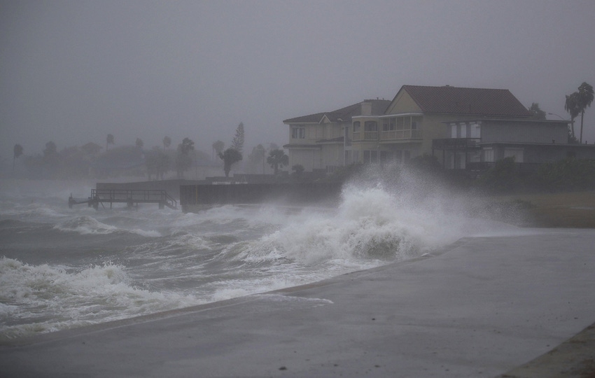
Hurricane Harvey roared on to the Texas coast late Friday as the first Category 4 storm to hit the U.S. in over 13 years, delivering deadly 135 mile per hour sustained winds and heavy rain, flooding streams and rivers, damaging and destroying homes, shutting down cotton gins and blowing away cotton storage modules in the Coastal Bend, leaving debris and destruction across a 100-mile swath from Corpus Christi up the coastline to Port Lavaca.
In addition to heavy damage in a number of communities, agricultural interests from the coast to nearly 130 miles inland suffered from wind damage and heavy flooding from unprecedented downpours that left as much as 15 feet of water on some fields and roads, stranding, scattering and destroying livestock on many farms.
Following initial widespread damages, loss of life and historic floods, the massive storm, downgraded to a tropical storm reversed its path and headed back to the Texas coastline and into warm Gulf waters, and is regaining strength and energy. Another landfall is expected at tropical storm strength near the Texas-Louisiana border, battering agricultural interests in the Pelican State. Cotton growers in Louisiana are now at risk of damages to fields and crops as they brace for a storm that will rack up three landfalls since forming in the Caribbean early last week.
Already, Harvey has caused massive flooding in the Houston-Beaumont area and has dropped extensive rain in both Southern Louisiana and in parts of Mississippi. In Houston, thousands of residents were forced from homes in what authorities are calling the worst flooding in the history of the state. Now weather forecasters and federal disaster officials are consulting with local authorities in New Orleans and other cities in Louisiana and emergency management officials in parts of Mississippi.
HISTORIC IMPACT
The National Weather Service (NWS) has described the impacts of Hurricane (and now Tropical Storm) Harvey as historic, saying the flooding associated with the resilient storm "are catastrophic and life threatening." Already from 36 to 48 inches of rain has fallen in the Houston area, with more rain in the forecast as the storm works its way back to shore. So far, eight victims have lost their lives as a result of the storm, and officials fear those numbers will quickly rise as rescue operations reach more areas hard hit by the storm.
The ports of Corpus Christi and Houston have temporarily ceased loading and shipping operations and may shut down completely for an extended period of time, delaying wheat shipments and forcing grain elevators to suspend operations through most of South and Southeast Texas. Port authorities in New Orleans and transport operations along the Mississippi may also be affected by the storm in the coming hours and days ahead. Corn and soybean exports could be adversely affected in the coming weeks as a result of storm delays and damages.
LIVESTOCK RESCUE UNDERWAY
In Texas, livestock recovery teams were hard at work Monday setting up temporary shelters for displaced or lost livestock, and are assisting ranchers in moving cattle rescued from flooded fields and rising waters.
Ginning officials in the mid-coast region of Texas say while some losses of baled cotton have been reported, additional problems are expected as a result of wet cotton, and conditions could also damage grain and soybeans in Texas and potentially in Louisiana.
In the Coastal Bend region of Texas, officials report the storm event comes on the heels of what some farmers are calling “a bumper cotton year."
The National Hurricane Prediction Center is warning Harvey will landfall again sometime on Wednesday causing a storm surge of up to 3 feet in Southeast Texas and across much of the Louisiana coast. An additional 10 to15 inches of rain are expected on the upper Texas coast and as much 5 to 7 inches of rain in parts of Southern Louisiana from Lake Charles to Morgan City. Heavy rainfall could also affect interior areas of Louisiana as the system tracks northeast across the state, bringing significant rains as far north as Little Rock, Arkansas, and Memphis, Tennessee. Tropical Storm-force winds will affect parts of Louisiana on Wednesday and possibly on Thursday.
LOUSIANA COTTON IN JEOPARDY
Daniel Fromme, Associate Professor and cotton and corn specialist at the LSU Dean Lee Research Station in Ale in the days ahead, and some lodging is possible for corn.
"We were preparing to defoliate cotton this week, but that will be delayed now. The leaves on cotton plants should give us some protection against the storm," he said. "About 80 percent of our corn has been harvested, and that will help, but we could see some lodging depending on how extreme the weather gets in Central Louisiana."
Fromme said the northern half of Louisiana is where most crop production takes place, and there is some concern for agricultural interests.
"We get about 60 inches of rainfall each year [in parts of Louisiana] and we are subject to flooding because we receive so much rain under normal conditions. It doesn't take much for us to experience flooding," he explained.
Rainfall totals in northern Louisiana however are expected to be far less than in southern portions of the state.
Meanwhile, the human drama in Southeast Texas continues to grow. Emergency officials in Harris County (including Houston) report 15,000 to 20,000 displaced residents are sheltering in various locations across Harris County, nearly 10,000 in the Houston Convention Center.
EXTREME DANGER FROM LEVEE
On Tuesday morning, U.S. Army Corp of Engineer officials warn that a levee at Columbia Lakes on the Brazos River in Brazoria County south of Houston has been breached. Mandatory evacuations were ordered in Fort Bend and Brazoria Counties on Monday as the Brazos rose toward historic heights, putting a string of levees at risk of failure. Officials warn that extreme flooding from the breach threatens thousands of residents in harm’s way.
The amount of water expected to hit Fort Bend County by late Tuesday could reach levels seen only about once every 800 years. Also, Addicks and Barker Reservoirs northwest of Houston are filled to capacity, and engineers fear dams at both lakes are subject to weakening and possible breaches. Already water is spilling over the dam at Addicks Reservoir.
A Harris County Flood Warning System rain gauge near Friendswood, Texas, reported a four-day storm total topping 48 inches through early Tuesday morning. The Weather Channel is reporting, if confirmed, it would be the heaviest storm total rainfall from any U.S. tropical cyclone in records dating back to 1950.
Officials warn current conditions and the forecast for more rain this week could develop into one of the worst flood disasters in U.S. history.
You May Also Like
Current Conditions for
48°F
Mostly Cloudy
Day 51º
Night 36º
Enter a zip code to see the weather conditions for a different location.


