
Subscribe to receive top agriculture news
Be informed daily with these free e-newsletters
October 10, 2014
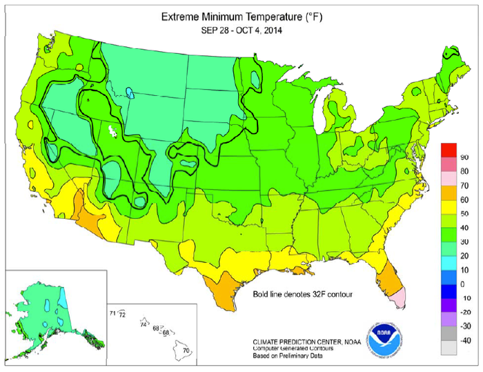
A late-week cold snap ended the growing season, roughly on schedule, across much of the Upper Midwest. Although the freeze was not unusually early, some crops were developmentally delayed due to late planting and a relatively cool summer. As a result, producers in freeze-affected areas monitored immature corn and soybeans for signs of injury.
By October 5, approximately 20 percent of the U.S. corn production area had experienced a freeze. Prior to the cold outbreak, much of the central and eastern U.S. had experienced several days of warm weather, followed by locally heavy rainfall.

Get more weather information and maps
Did you know you can get weather information on csdigest.com? We’ve got current weather, forecasts, radar and ag weather maps right here!
Some of the heaviest precipitation, locally 2 to 4 inches or more, fell in the middle Mississippi and lower Missouri Valleys. Rain also soaked portions of the Deep South and the northern High Plains—especially an area centered on western sections of Nebraska and South Dakota .
In contrast, mostly dry weather prevailed from the Pacific Coast to the southern Plains. Initially, a period of cool weather dominated the West. However, record-setting warmth arrived along the Pacific Coast during the second half of the week and gradually spread inland. As a result, late-week temperatures reached or exceeded 100° F in parts of California and the desert Southwest .
All graphics courtesy of USDA, NOAA, Department of Commerce
You May Also Like
Current Conditions for
48°F
Mostly Cloudy
Day 51º
Night 36º
Enter a zip code to see the weather conditions for a different location.


