Subscribe to receive top agriculture news
Be informed daily with these free e-newsletters
July 30, 2015
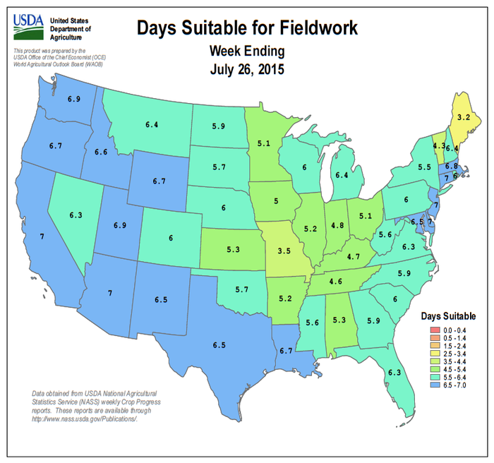
In the north, cooler, drier air pushed into much of the Midwest, although showers lingered across the southern and western Corn Belt. In particular, rainfall totals of 1 to 2 inches or more were common across Missouri and southern Illinois. Across the remainder of the lower Midwest, favorably dry weather allowed water to drain or evaporate from still-soggy fields.
Heat baked the south-central U.S., increasing crop stress in an area that had experienced significant flooding just two months ago. Triple-digit high temperatures were reported as far north as the central Plains, although rain helped to offset the effects of the heat in southern Kansas, northern Oklahoma, and the Texas panhandle.
Meanwhile, hot, humid weather across the South pushed weekly temperatures at least 5°F above normal in several locations from the Mississippi Delta into Georgia and South Carolina. Scattered showers, heaviest in the southern Atlantic region, partially offset the effects of heat in some areas, but bypassed the western Gulf Coast region and parts of the interior Southeast.
Elsewhere, cool, showery weather from southern California to the Intermountain region contrasted with warm, mostly dry conditions across the northern tier of the West. Early-week showers in southern California, associated with the remnants of Hurricane Dolores, were highly unusual for this time of year.
You May Also Like
Enter a zip code to see the weather conditions for a different location.