

Subscribe to receive top agriculture news
Be informed daily with these free e-newsletters

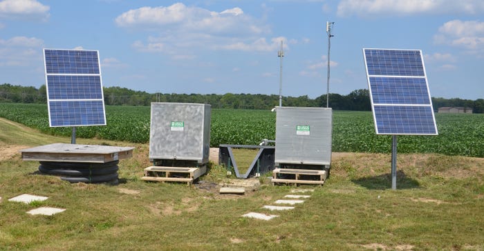
Slideshow: Allen County SWCD watershed project includes USGS automatic water sampling site.
If you drive along Bull Rapids Road near Harlan in northeastern Allen County, Ind., you’ll see a bank of equipment semipermanently situated in a grassy area just outside a crop field. There’s a similar set of monitoring equipment on the other side of the road, farther west in the field. This sophisticated equipment was installed by the U.S. Geological Survey to help get answers about field runoff of nutrients in different types of tillage systems.
“That area of the county is in the Black Creek Watershed Project administered by the Allen County Soil and Water Conservation District,” says Kate Sanders, manager of the project until just recently. She moved into a role as an Indiana State Department of Agriculture resource specialist with the Division of Soil Conservation. Courtney Scherer took her place as the watershed project manager.
“We were thrilled that USGS decided to install automatic water sampling equipment at this location so we could learn more about sediment and nutrient movement in water under different conservation systems over time,” Sanders says.
Purpose of project
Ed Dobrowolski is project chief for the automatic water sampling project in Allen County. Located in Indianapolis, he can make changes to sampling protocol remotely by cellphone or laptop. However, once samples are collected, they must be picked up and prepared for shipping to a lab by hand. The Allen County SWCD became his boots on the ground for the project, Sanders says.
The five-year USGS automatic water sampling project began in 2015. “The goal is to treat both the field on the east side of the road and on the west side the same for three years,” Sanders explains. “That should provide a baseline for water, sediment and nutrient movement in conventional [no-till] systems. Then one field will be converted to [add] cover crops and more environmentally friendly fertilizer application processes while the other stays in no-till [only]. The goal is to determine if differences occur in water and nutrient movement once cover crops are part of the system.”
The equipment used for sampling is rather sophisticated. Refer to the descriptions with the pictures in the slideshow to learn more about the equipment.
“One of the challenges was getting the farmers to go along with farming the fields conventionally at first,” Sanders says. “They already use no-till and cover crops, and are sold on the advantage of that system.”
Other water monitoring
The Allen County SWCD has also conducted a grab-sample water monitoring project since 1996. The actual sampling is contracted through Indiana University-Purdue University Fort Wayne. Sanders worked on the project while a student, collecting samples on a routine basis.
“It started when there were questions about atrazine in Fort Wayne’s drinking water,” she recalls. “Today they’re looking more for sediment and nutrients. The grab-sample route consists of 24 stops. A sample is pulled at each stop each time.
“The goal so far is using this information to follow trends, and to make decisions on where available cost-share money is needed most to make improvements,” she says. “It helps conservation leaders prioritize problem areas where cost share could help farmers get practices on the land first. It’s also used to make decisions about location of automatic water testing equipment.”
Anyone can access the data collected so far in the grab-sample program through the Water Quality Information Service, Sanders notes. It’s stored on the IPFW website.
You May Also Like
Current Conditions for
51°F
Mostly Cloudy
Day 64º
Night 41º
Enter a zip code to see the weather conditions for a different location.


