July 8, 2019

Nearly $2 million in projects are planned for construction this summer to slow and treat stormwater from more than 1,200 acres of mostly farmland in the Dobbins Creek headwaters.
Reduced flooding and improved water quality are goals of the projects led by the Cedar River Watershed District. They are part of CRWD’s overall capital improvement plan, a nearly $9 million, 25-project initiative that started in 2016.
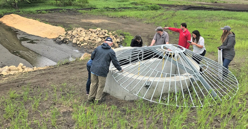
All located southeast of Brownsdale, the four projects will construct earthen berms in Dexter and Red Rock townships, north of Interstate 90. The berms will capture and slowly release large amounts of stormwater, allowing much of the rain water’s sediment — often containing excess nutrients, chemicals and bacteria — to settle out in each project��’s basin.
Once released from the berms, the treated stormwater will flow into either one of Dobbins Creek’s branches before they converge at Austin’s Jay C. Hormel Nature Center and flow into East Side Lake and the Cedar River State Water Trail.
“It’s exciting to be moving forward with more projects that will make a difference in our watershed,” says Cody Fox, CRWD project manager. “None of this would be happening without the partnerships that we continue to make with landowners, farmers and township officials.”
The CRWD board of managers recently approved bids on three of the projects, totaling nearly $1.7 million, in Red Rock Township. Earlier this spring, the board approved a $364,000 project, Dexter 30, in Dexter Township.
Details on the projects include:
• Dexter 30. Located in the headwaters of Dobbins Creek’s south branch, this project will slow and treat stormwater from 490 acres in Dexter Township. It also will protect 30 acres of mostly former cropland by putting the land under a permanent conservation easement with the watershed district, creating wildlife habitat.

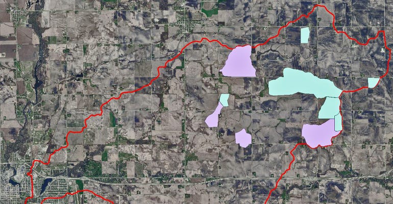
SITE SPECIFIC: Dobbins Creek Watershed is outlined in red with the lower-left corner including Austin’s East Side Lake, which is created by a dam on Dobbins. Green areas show land sections in which stormwater is slowed and treated by CRWD Capital Improvement Plan projects completed through 2018. Purple areas show land that will be treated through four CIP projects to be built in 2019.

• 250th Street. About 470 acres will drain to this project site on the north side of 250th Street (southeast of Brownsdale) in Red Rock Township. Stormwater will be slowed and treated on a tributary stream that connects nearby to Dobbins Creek’s north branch. Watershed modeling suggests that the frequency of stormwater overtopping 250th Street will be reduced immediately downstream of the project.
• Red Rock 26 and Red Rock 27. These similar-sized projects in the South Dobbins’ headwaters in Red Rock Township will slow and treat stormwater from about 125 acres each or 250 acres combined.
With these projects, CRWD overall will have field structures in place to slow and treat stormwater flowing from more than 2,200 acres of mostly cropland in the Dobbins watershed or about 8% of its overall land.
CRWD is working to finalize two additional capital improvement plan structures for construction later this year that also are in the Dobbins Creek watershed. Dobbins is targeted heavily by CRWD due to its propensity for flash flooding that causes water quality issues and flood damage to rural and urban infrastructure and properties.
Under the capital improvement plan initiative, upland water storage is a focus because it decreases the amount and speed of stormwater flow, which reduces the potential for significant downstream streambank erosion.
To date, CRWD has completed nine of 25 projects that have an overall goal to reduce flooding by 8% at the Cedar River-Dobbins Creek confluence in southeast Austin.
Go online to view an interactive story map and download photos related to completed CIP projects by CRWD.
Source: Cedar River Watershed District, which is solely responsible for the information provided and is wholly owned by the source. Informa Business Media and all its subsidiaries are not responsible for any of the content contained in this information asset.
You May Also Like


