March 14, 2023
Have you ever stood on a piece of ground and wondered about its history? Wondered what it was like when the pioneers first stepped onto it? Where can you find that history?
With vehicles, you have Carfax.com where you can look up your car or truck. And for your family tree, there’s a plethora of websites to dive into.
But what’s out there for farmland? Quite honestly, not much.
You could purchase what is called an abstract of title. This is a document that summarizes the history of a property’s ownership, including transfers of ownership, liens, judgments and other legal documents that affect the property’s title. It is usually prepared by a title company or an attorney, which can get costly. I don’t know about you, but when I’m looking to scratch my idle curiosity itch, I much prefer free.
A few months ago, I came across a couple of interesting websites. While they don’t tell you the whole history of your farm, they do tell you who originally bought it from the U.S. government.
This information can be found on the land records pages of the Bureau of Land Management and the Illinois Secretary of State websites.
Public Land Survey System
The easiest way I found to use these websites is to describe where the property is located in legal terms. For Illinois, that means using the Rectangular Land Survey System, also known as the Public Land Survey System.
To describe the location of a specific piece of land using the Public Land Survey System, you typically provide its township and range, along with the section number. For example, if you were interested in a parcel of land located in Township 3 North, Range 2 East, Section 16, you would describe it as being located in “T3N R2E Sec 16.”
More information on how to discern the legal description of your farm using this system can be found on the Illinois Secretary of State Public Domain Land Sales website.
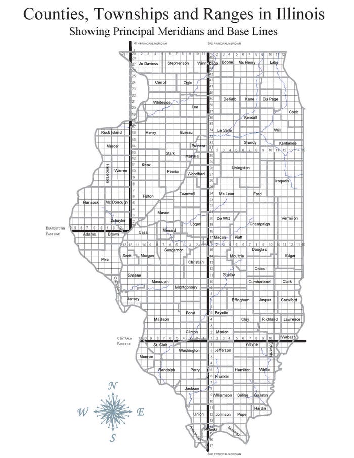
RECTANGULAR SYSTEM: To begin to research a farm, you’ll need its description in legal terms — and that starts with using the Rectangular Land Survey System, also known as the Public Land Survey System. (Images courtesy of Michael Lauher)
If you don’t have this information readily available for the farm you want to research, I’ve found the website Acrevalue to be a very easy place to find this information. Just go to the map, zoom to the farm, and the township, range and section number pop up. The meridian number isn’t as obvious, but for Illinois, it will either be the 2nd, 3rd or 4th principal meridian, depending on whether the farm is located in the eastern, middle or western part of the state.
Rolling Acres Farm
I named my company, Rolling Acres Ag Solutions, after the farm my grandfather purchased in 1960 in southwestern Edgar County, Ill. It is where my brother, sisters and I, and all of our cousins, spent many years learning the kinds of life lessons you get if you’re lucky enough to grow up on a farm.
I went to the U.S. Department of the Interior Bureau of Land Management’s website page for land records. From there I clicked on Land Patents, selected the state and county, and plugged in the township, range, section and meridian where the Rolling Acres farm is located. It provided me with a list of all the men who bought land in that section. I looked for the ones who bought the ground in the quarter section and found that the farm was originally purchased in two pieces by two different men.
James Wilson and Jacob Crist were the original purchasers of the Rolling Acres Farm in 1831 and 1834, respectively. I was able to view an image of the original documents, where Wilson’s patent was actually signed by President Andrew Jackson. By 1833, there was a backlog of over 10,000 patents to be signed, due to the westward expansion — and the duty to sign the patents was reassigned to the commissioner of the General Land Office.
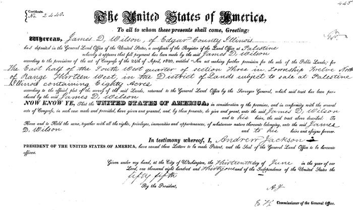
SIGNED: This document verified that James Wilson bought 80 acres of public lands from the U.S. government in 1831 — signed by President Andrew Jackson. He paid $1.25 an acre, which would be about $40 today.
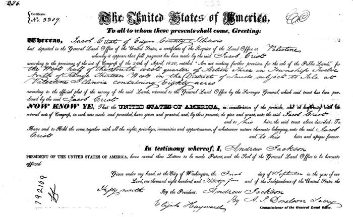
SOLD: Jacob Crist bought 80 acres of public lands from the U.S. government in 1834. This document was also signed by the president, and Crist paid $1.25 an acre. Decades later, each of these farms would be part of my family farm.
The Illinois Public Domain Land Tract Sales page of the Illinois Secretary of State’s website provided more information. When I plugged in the township, range, section and meridian information into that database, I discovered each man purchased the ground for $1.25 per acre. That is just under $40 per acre in today’s money.
From the state’s website there was a quick link to view a copy of the original plat from the original survey located at the Illinois Digital Archive. For the township where the Rolling Acres farm is located, the original survey noted some of the features of the terrain such as timber, prairie and swamp ground.
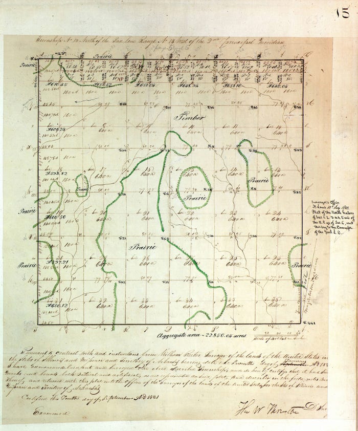
1ST PLAT: I found the original plat map from the first survey of my family’s farm, purchased from the federal government in 1831.
It was an interesting journey to be sure. While the information I gleaned from this search didn’t give me a whole picture of the farm’s history, it did make me feel a little closer to my roots.
Lauher owns Rolling Acres Ag Solutions and is a member of the Illinois Society of Professional Farm Managers and Rural Appraisers. Email questions to [email protected].
Read more about:
FarmlandAbout the Author(s)
You May Also Like


