Subscribe to receive top agriculture news
Be informed daily with these free e-newsletters

Remote sensing gains a foothold in crop management for a number of reasons, including UAV use.
Unless you’ve been living in a cave on a remote island in the Pacific Ocean, you should already know the use of unmanned aerial vehicle technology has exploded over the last couple of years.
The use of remote sensing in agriculture isn’t new. But as UAV and digital camera technologies have improved and become more affordable, so have the reliability, accuracy and cost-effectiveness of using remote sensing in agricultural settings.
“We’re working to improve the effectiveness of weed control with chemicals, but on a cost-effective basis,” explains Kevin Price, an executive vice president of research and technology development at AgPixel LLC, who retired from Kansas State University last year after 27 years in higher education. “We’re not trying to replace agronomists. ... We’re trying to enable them to do a better job.”
Based in Johnston, Iowa, AgPixel’s team of remote sensing and geospatial analysis experts assist their customers through the use of UAVs and manned aircraft to gather, process and analyze agricultural data, usually within the next business day. Using the images captured, growers can: detect areas of stress early, calculate the amount of acres damaged by weather or infestation, reduce the time needed for crop scouting, create better chemical treatment plans and more.
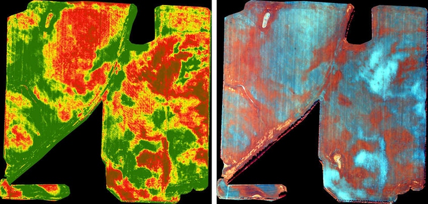
Better maps
“Part of the problem is, most growers don’t have a good map that shows them where their problems areas are. So our goal is to take high-quality imagery and turn it into actionable information,” offers Price.
With advancements in camera technology, getting good images isn’t an issue. For example, Price says a piloted Cessna aircraft can capture 4-inch resolution images flying at 3,000 feet, while a UAV flying at 400 feet can capture images at 1-inch resolution. More importantly, the distances covered by either method are much greater than what can normally be done using traditional crop scouting and/or mapping methods.
For example, Price explains, a Cessna can map 20,000 to 30,000 acres on a good day, while a UAV can cover 1,000 acres per day.
“For weed control, there’s no question a low-flying drone, or a Cessna using high-resolution camera technology is an accurate way to see what’s going on in a field,” explains Price, who notes you can identify weeds by their different shapes and growing patterns.
Kristina Polziehn, an agronomist and owner of Axiom Agronomy in Alberta, Canada, uses drones as a part of her services and has seen firsthand the benefits of using remote sensing technology to identify problems in fields. (Note: Canada has different rules regarding UAV use that are more liberal than those of the United States … for now).
“More growers should be using remote sensing technology as a tool for weed management to detect how widespread weed problems are in fields, detect herbicide-resistant weed patches and to track herbicide-resistant patches from year to year,” says Polziehn. “By using this information, growers and agronomists can be more informed on the severity of the weed population and more targeted in the control options required to manage those weed populations.”
- Yontz writes from Urbandale, Iowa.
Solution Center is independently produced by Penton Agriculture through support from SureStart® II herbicide. For more information, visit GetMoreTime.com.
You May Also Like
Enter a zip code to see the weather conditions for a different location.


