

Subscribe to receive top agriculture news
Be informed daily with these free e-newsletters

Slideshow: For Laura and Nate Thompson, multispectral imagery lets them see things not yet apparent to the naked eye to respond to crop needs.
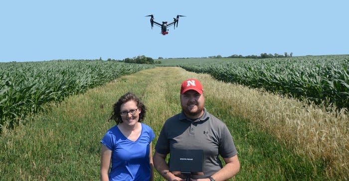
Laura Thompson got her start with aerial imagery at an early age. Her dad, Dean Stevens, a farmer and pilot, flies a powered parachute, and often took her along for flights over crop fields when she was growing up on the farm.
"It's like an ultralight plane with no cab," explains Laura, a Nebraska Extension educator. "We would fly over and look at fields. That was some early exposure to me to have an aerial perspective and what patterns will emerge from the air."
Laura's husband, Nate, has a background in soil science and geographic information systems as a soil conservationist with the Natural Resources Conservation Service. "We use imagery and GIS applications every single today. It's a big part of our work," Nate says. "We use maps to identify areas in need of either structural practices or identifying areas for vegetative practices like cover crops."
So, as regulations became more certain surrounding use of unmanned aerial systems, it was a natural next step that Laura and Nate would earn their UAS pilot certifications in late 2016, after Part 107 Federal Aviation Administration regulations went into effect.
They also saw a benefit to using onboard cameras to look at crops outside the visible spectrum and see patterns not apparent to the naked eye. While Laura and Nate have primarily been using their drone on their family farms near Falls City, they are now providing the benefit of aerial imagery and prescription services to other growers in southeast Nebraska, northeast Kansas and northwest Missouri.
Filling a need
While aerial imagery is available from airplanes and satellites, the Thompsons realized early on that UASs fill a unique role in the market. "Where the drone stands out and has an advantage is being able to have that imagery on demand. If you have a problem, you're able to just go out and get that imagery right away," Laura says. "Also, the imagery is at a really high resolution. I'm amazed at how detailed the imagery can be with the drone, and how well we can see individual plants."
To get started, they had to figure out what kind of UAS to use — rotary or fixed wing. With a quadcopter offering them more maneuverability, as well as the ability to launch a drone for a quick look at a field from overhead, they've been using a DJI Inspire 2 quadcopter for the last two years.
They also needed to measure reflectance from the crop canopy in five bands on the electromagnetic spectrum — red, blue, green, near infrared and red edge. So, they mounted a RedEdge sensor by MicaSense to the drone.
In addition to the GPS on the UAS itself, the camera also has a GPS unit to geo-reference the images it captures. This, along with high-resolution imagery, means the UAS is equipped for early-season scouting for weeds, diseases and insects, as well as picking out areas of sprayer skips and evaluating stands.
However, with the ability to measure crop reflectance in five different bands, where the UAS really stands out is measuring patterns that aren't visible to the naked eye. "A lot of people go out and buy a drone with a standard camera for scouting, but multi-spectral sensors let you see things you normally wouldn't see," Nate says.
Imagery in 5 bands
Last year, Laura's parents, Dean and Deb Stevens, with the help of Laura and Nate, began a study funded by a Sustainable Agriculture Research and Education grant to test in-season nitrogen prescriptions generated by aerial imagery using vegetation indices.
Combining those five different bands, they can measure normalized difference vegetation index (NDVI), normalized difference red edge (NDRE), or other indices used to calculate biomass or crop health in fields. The NDRE index is similar to NDVI, but by using the red edge band, as opposed to the red band, NDRE is better able to measure biomass differences later in the season, Laura says.
"With NDVI, as higher biomass crops get a more complete canopy, the index starts to saturate and you aren't able to differentiate as well between different levels of biomass, or in our case different nitrogen needs," she explains. "Both indices use near infrared, but with NDRE, we're measuring the red edge band, which is moving closer to the infrared end of the electromagnetic spectrum. This portion of the spectrum is more responsive later in the growing season."
"The near infrared and red edge measurements are correlated to chlorophyll content and overall plant biomass. We're using that index as an indicator of nitrogen need. It really shows the difference we wouldn't see," adds Nate. "In this area, a lot of nitrogen is put on as pre-plant anhydrous. Our goal is to put on less as anhydrous, and then develop in-season, variable-rate nitrogen prescriptions that are responsive to what is needed for that year."
Using the NDRE index, Laura says they are using the crop itself as a sensor.
"On those fields, we're setting up blocks within the field where the producer puts an ample amount of N as a reference. When we fly over the field, we're able to compare the rest of the field to that reference block and monitor the field to determine where and how much additional N is needed," she says.
Pinpointing deficiencies
The first year, they compared three base rates — a 160-pound rate for a check strip, and two drone-managed strips with base rates of 75 and 100 pounds per acre. In late June, they flew the field, and, using the imagery collected, made a variable-rate prescription for the drone-managed strips, while applying a flat 40 pounds per acre on the check strip. That first year, they saved about 25 pounds of nitrogen by using the drone and sensor prescriptions on a whole field basis, with no yield reduction. They're continuing the project this year, with a single drone-managed strip with a 100-pound base rate compared to check strips of the farmers' traditional management.
Laura and Nate note using a drone made it easy to capture images quickly and at a high resolution, and by flying the field frequently, to determine when the different treatments started to show signs of deficiency.
"We flew the field a lot. We wanted to know when the corn would show differences compared to the reference," Nate says. "If we developed the prescription too early, before N differences started to show up, we might under apply N. By flying frequently, we can time the N application to when we start to see differences in the imagery, but before they become severe. The big advantage with the multispectral sensor is you can detect deficiency early on. You can see it with the sensor before it's visible to the naked eye and take action."
"Looking at regular color imagery versus imagery using near infrared of the spectrum, it's amazing how much you can see N deficiency showing up that you don't see with your eyes when you look at the field." Laura says. "We're hoping to continue this study. And as environmental conditions and nitrogen needs change in a given year, we'll see how the sensor helps us be more responsive in managing our nitrogen."
You can follow Laura and Nate's projects and learn more online at www.goodlifeag.com.
You May Also Like
Enter a zip code to see the weather conditions for a different location.


