Subscribe to receive top agriculture news
Be informed daily with these free e-newsletters

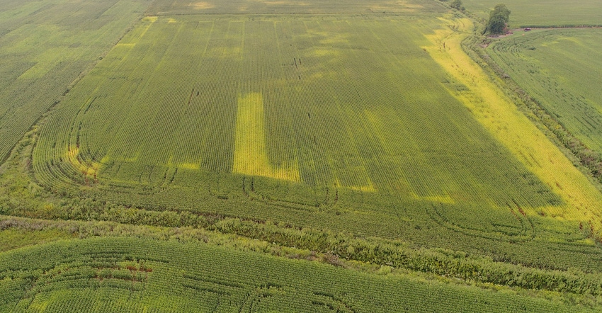
Technology provides more options for gathering scouting information.
November 20, 2017
By Rachel Flanders and Shelby Riley
In agriculture, technology is constantly evolving. Modern farming is like a machine with several parts that work together to attain a high yield and make a profit. A large component of this agricultural machine is technology, such as aerial imagery that is being embraced by many growers.
Noblesville, Ind., grower Jim Flanders says it would be useful to sit down with salespeople for different aerial imagery technologies and ask them the positives and negatives of each. There are three main options for obtaining aerial imagery today: planes, unmanned aerial vehicles and satellites. If you could talk to people who are knowledgeable about each option, you should be able to make a logical decision for your farm.
“Utilizing any of the technologies farmers have coming at them is a matter of where you are at now, and how much more data can you pay for and actually glean productive information from,” says Flanders.
Closer look
Here is a quick look at these technologies, and some advantages and disadvantages of each.
Why planes? Scalability is the main advantage when using manned aircraft, says AirScout Senior Agronomist Maykol Hernandez and IntelinAir Senior Agronomist Ivan Dozier.
Unlike satellite imagery that captures distant pictures dependent on weather, and UAVs that take close pictures, airplanes capture images from a larger scale. More data per day is produced with manned aircraft, says Hernandez.
AirScout and IntelinAir are startup companies that offer packages including 10 flights per year and several different types of images and tools to analyze data.
Growers can get the “best of both worlds,” according to Dozier. You get a unique perspective that is in between drones and satellite imagery.
AirScout offers thermal imagery that detects three one-hundredths of a degree Celsius to find stressed areas in the field, Hernandez says.
Plane technology “gives proper tools to be able to execute” scouting and management on the farm, says Hernandez. By embracing these tools, growers can see weed, disease and insect pressure; manage irrigation; identify stressed crops; know when to apply nitrogen; and find flooded spots to replant.
Why not planes? One setback of manned aircraft is the expense. Growers pay a one-time fee of $4 to $10 per acre, which covers 10 flights, according to Hernandez and Dozier. For example, if your farm is 500 acres and the fee is $6 per acre, you pay $3,000 one time and get images 10 times throughout the year.
Furthermore, it’s important fields are clustered together to reduce fuel waste, notes Dozier. Much fuel is wasted when fields are farther away from another.
For plane technology to improve, the speed of collection and data processing must be quicker. When the turnaround time, currently 24 to 48 hours, is shortened, growers will be able to use data more effectively.
Why UAVs? Currently, drone technology is best used as a supporting tool.
“Aerial imagery can improve the efficiency of your crop scouting by going only to the worst spots of the field,” says Purdue University Extension corn specialist Bob Nielsen. While drones cannot replace walking fields, they still save time and collect useful data.
Growers can use drones to capture aerial shots of test strips and can help identify varietal differences throughout the growing season for comparative purposes, says DuPont Pioneer Regional Agronomist Ryan Piel.
Why not UAVs? To fly a UAV, operators must obtain a remote pilot certificate to comply with Federal Aviation Administration regulations. That takes time and money.
According to Nielsen, the FAA exam is a 60-question multiple-choice test based on a wide range of drone regulations and aeronautical knowledge. It costs $150, so there’s financial incentive to pass it the first time.
Also, because drones cannot replace walking fields, their usefulness still relies on agronomic knowledge, says Nielsen.
Cost is a big factor when it comes to drones. Nielsen uses a Phantom 4 Pro model, which costs about $1,500. He believes it’s economically beneficial for growers to have their own UAV so they can use it whenever they need to.
It’s a good investment, says Nielsen. There are models that cost less and work just as well as a more expensive model. There is a wide range of costs depending on camera quality and other features.
Why satellite imagery? Satellite imagery doesn’t require a human pilot. It’s the ultimate hands-off option, according to Dozier.
“Convenience, consistency and affordability” are the best aspects of satellite imagery, says FarmLogs Senior Product Marketing Manager Shepherd Whitcomb.
This technology is effortless and easy, Whitcomb says. Growers don’t have to stitch any images together.
Images are delivered weekly, taken from the same exact place, and scaling is always appropriate.
Satellite imagery is very affordable. Growers pay $100 per month for a farm up to 5,000 acres, according to Whitcomb. It’s the same cost to capture images of fields far away from each other or near each other.
Images are captured all week from FarmLogs’ 140 satellites, and employees sort out the best images that are sent to growers.
Why not satellite imagery? Weather, specifically cloud cover, is the biggest challenge of using satellite images, according to Piel. Satellite imagery is reliant on nearly perfect weather conditions to capture clear images.
Another downfall is resolution, or how fine the pixels are in the pictures of the images.
FarmLogs’ current resolution is 3 meters on the physical ground, according to Whitcomb. In the future, the company hopes to have smaller resolution to be able to identify individual plants.
If growers are trying to take stand counts of a field from these images, the resolution isn’t high enough, he says. But if they use a drone to aid in a stand count, those images can be saved in their FarmLogs account for later reference.
Make the leap
“In the very near future, we’ll get to the point when aerial imagery is a necessity on the farm,” says Dozier. Growers will decide which aerial imagery technology to use.
“Each of the technologies keep improving,” says Flanders, the farmer from Indiana. “This is likely the best thing for the farmer — good competition between companies and technologies to make each of them better to bring a better overall product to the farm customer.”
Manned aircraft, drones and satellite imagery each has its place in the ag industry, but maybe one fits better on your farm.
“The sky’s the limit when it comes to aerial imagery technology,” Dozier says with a chuckle.
Flanders and Riley are seniors in ag communication at Purdue University. Jim Flanders is the co-author’s father.
You May Also Like
Enter a zip code to see the weather conditions for a different location.


