

Subscribe to receive top agriculture news
Be informed daily with these free e-newsletters

TerrAvion is taking data analytics to a new place with its cloud-based imaging program.
February 7, 2017
What if you could have an aerial image taken in the morning and have a full analysis available for download within 24 hours? Sound crazy? Not to Robert Morris, founder and head of TerrAvion, an aerial imaging business that recently picked up new funding to keep pushing the business forward.
The company has been on the move, recently announcing new partnerships with ag consulting firm Servi-Tech and FarmSolutions, both companies that serve the precision ag industry. By partnering with TerrAvion, they get access to high-level aerial imagery, and specialized maps, quickly.
Morris is no stranger to the power of aerial imagery. In the armed forces, he ran a drone platoon, but when he got out of the service and was approached by others to put that knowledge to work he balked. "I had two farmer friends and they had a problem," Morris recalls. "The needed to make decisions and get around their farms to see what was going on."
He recalls that they thought a drone would be the best idea, and Morris offered a different solution - aerial imagery shot from airplanes. "We can deliver Google Earth quality images cheaply, and provide the analysis as part of the service," Morris says.
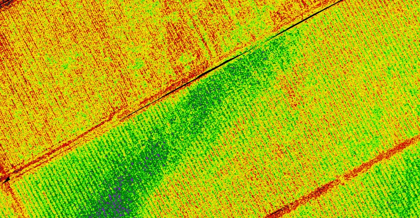
But that was just the start. Familiar with aerial imagery, Morris figured there would be a way to automate the preparation of final images, which would also make those images available in a useful form more quickly. The result is TerrAvion a firm that is constantly gathering images and moving them through the company's proprietary image system to provide customers with aerial photographs, normalized vegetative difference index maps, thermal images, customer color maps and histograms and all at resolutions high enough to see individual plants.
By partnering with firms like ServiTech and FarmSolutions, farmers will have access not only to more accurate and frequent aerial imagery, but the agronomic support to go with it. "What does NDVI mean, or what might I want to look for in an NDVI image?" Morris asks. "ServiTech can help make that decision with a farmer."
TerrAvion brings the expertise of gathering and processing a vast amount of imagery quickly and easily, while the agronomy-focused partners can incorporate those images into higher-level decision-making.
Morris runs through some quick scenarios where this level of imagery pays off including knowing soil temperatures on a field-level basis to manage planting; or how about the driest fields at harvest time to get combines rolling? Both are possible with the data provided. "You can get 10% of your gross revenue to the bottom line and it's possible by doing stupid simple things that add up, like avoiding drying charges or making sure the whole crop has germinated," he notes.
Getting planes
One question is availability of aircraft to fly those fields as TerrAvion expands across the country. For Morris that answer is simple: "It turns out there's a huge supply of underutilized general aviation aircraft out there," he says. "Every dentist in America seems to have bought a Cessna that's at a local airfield."
As for pilots? There' a solid population of pilots with commercial licenses that dream of being a commercial pilot but they need more hours in the air. Working with TerraAvion that's possible. The company is marrying the available plane with the hours-needed pilot to get aerial imagery.
The company is growing rapidly. Morris notes they've imaged several hundred thousand acres and plans to be in the millions of acres for 2017. To help fund that expansion of coverage, the company recently announced it had received $10 million in Series A financing let by Merus Capital, with participation by Promus Ventures, Initialized Capital and 10x Group.
With the funding, TerrAvion will expand into the Great Plains, Mississippi Delta and the Pacific Northwest.
The world of aerial imagery has expanded. For years specialty crop growers have used images to improve products and profits. TerrAvion's advanced tech and cloud-based approach to data access offers a cutting-edge approach to aerial imagery that offers benefits to traditional row crop operations. Learn more about the service at terravion.com.
You May Also Like
Enter a zip code to see the weather conditions for a different location.


