

Subscribe to receive top agriculture news
Be informed daily with these free e-newsletters

Satshot, a longtime aerial imagery provider, expands its offerings with a new image source enhance app.
November 16, 2017
Satellite imagery has been around since NASA launched the first Landsat satellite in 1972. And while Landsat imagery is still being provided on a regular basis, the skies are filling with more cameras looking down on farmland. The key is that these newer birds are getting much more precise.
A newer provider of imagery for agriculture is Airbus Defense and Space; the same company that also builds passenger aircraft has an imaging business as well. That firm has teamed with Satshot, the Fargo, N.D. imaging firm, to offer data for agriculture.
“We added the high-resolution submeter imaging system from Airbus,” says Lanny Faleide, Satshot founder and president. “This is imagery at 1-meter resolution — comparable to aerial photography taken from an airplane, but more scalable.”
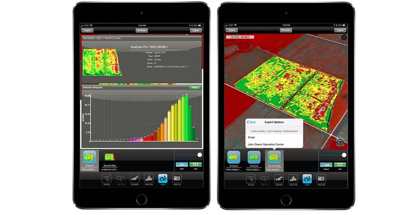
Satshot works with a wide range of imaging sources. Adding the Airbus SPOT satellite data expands on that. The company’s addition of these images enhances the firm’s offering and expands on Landscout, an iPad app that brings in those images for your farm and allows you to make in-season decisions for fertilizer and pesticide application.
In 2017, Satshot integrated Landscout with the John Deere Operations Center system. “You can import your field boundaries in from John Deere and build an application map using satellite imagery,” Faleide says. “That application map and plan can be uploaded to your John Deere monitor right in the cab.”
Faleide says that this implementation of imagery software combined with variable-rate-control information gives farmers more control. And working with a crop consultant or agronomist, this information provides enhanced precision for using crop protection tools.
“With precision agriculture, we need to get the farmer to understand and use the agronomy that they know firsthand in that field, and have confidence in making the decision,” Faleide says. The precision imagery offered through Landscout can offer that because the farmer can “see” issues on a field scale — and through that information and his own understanding of the field, make better decisions.
The Landscout tool is an adviser tool and a farmer tool. The agronomist or crop consultant working with farmers can control different levels of use for analyzing what’s happening in the field. In 2017, Satshot was providing biweekly to monthly images for customers.
Adding imagery
It’s possible, as these new satellite image sources are added, that more imagery can be captured in-season. The value is that satellite imagery covers a lot of territory quickly. Satshot is building on those Airbus images to provide even higher resolution through advanced image processing tools as well.
“We’ve taken the available data, and added other processes to make the resolution higher-quality,” he says. “We’ve merged the high-resolution grayscale image with the lower resolution multispectral image to create a much more accurate viewable product — and this is scalable across the continent.”
He explained that farmers need to understand what scalability means. It’s possible for a satellite, in a single pass, to image millions of acres in minutes that can be pulled into individual field maps for decision-making; and this can be done faster than some other methods, with less upfront labor. Faleide works with images from airplanes and drones, but he sees higher value in the rising availability of satellite imagery.
He adds that as more satellites have gone up, more of those companies are turning their attention to agriculture. “We’re being approached by more companies, and we try work with all of them,” he says, rattling off a list of satellite firms that may surprise those who don’t know how many eyes are actually in the sky. “With the Airbus imagery it’s higher-resolution. They can count bins, count cars in the field and look at fields in much greater detail.”
The hookup with John Deere is exciting to Faleide, who notes that it’s now possible to “turn that sprayer, nutrient applicator and planter into a more intelligent machine with this system.”
Adds Nathan Faleide, Lanny’s son and the Satshot CEO: “We’ve been in this imagery game for more than 20 years, and we’ve seen a lot. We understand the value of different levels of imagery resolution.”
Levels of resolution
Nathan explains that the firm starts with the free imagery from Sentinel (a European satellite constellation), which operates at 10-meter resolution. When matched with field boundaries, this level of imagery gives you an ideal view of crop health.
However, to make more accurate decisions, you need higher resolution. That usually means moving to the 10-meter resolution imagery the firm offers. “For $1,000 per user per year, we will provide them all the medium- to low-resolution imagery available for their fields — and that’s 90% of what most people want,” says Nathan. “This is not daily imagery: You don’t need daily imagery, you always need the right image … the image that makes sense.”
The next-level, high-resolution imagery, which starts at 50 cents per acre per image (so $50 for a 100-acre field) on an à la carte basis, may be a way to start. Nathan explains the higher-resolution image can provide confidence in a pattern seen in lower-resolution imagery.
During 2017, the firm also offered a $1-per-acre deal that provided the high-rez imagery for every field on a monthly or better basis. The firm is looking ahead at 2018 for new pricing, and there’s potential for even higher-resolution images to be available.
“We’re a middleman between ag and space,” says Faleide. “We bring volumes of data in our very advanced Satshot cloud system, and with the Airbus connection we were able to shoot the Corn Belt from the Red River Valley through western Ohio — 200 million acres between two and 10 times this summer, and with 90% clean images.”
That level of scalability and image quality will be more important for in-season moves. Having that access and information on tap, through an iPad app linked to John Deere Operations Center, puts more control into the farmer’s hands. A longtime goal for Faleide.
For more information, visit satshot.com.
You May Also Like
Enter a zip code to see the weather conditions for a different location.


